Highway 37 | ||||
|---|---|---|---|---|
| Ruta 37 | ||||
| Route information | ||||
| Maintained by Puerto Rico DTPW | ||||
| Length | 6.8 km[1] (4.2 mi) | |||
| Major junctions | ||||
| West end | ||||
| East end | ||||
| Location | ||||
| Country | United States | |||
| Territory | Puerto Rico | |||
| Municipalities | San Juan, Carolina | |||
| Highway system | ||||
| ||||
Puerto Rico Highway 37 (PR-37) is an urban road between San Juan (in Santurce area) and Carolina (in Isla Verde area).[2] In Santurce is known as Calle Loíza and the Isla Verde area is known as Avenida Isla Verde.
Route description
It is the main road in Isla Verde. The hotel zone of Isla Verde is located on this road and is located near Luis Muñoz Marín International Airport. Also, on this road lies the Luis Llorens Torres public housing.
Among their intersections are the PR-187, to Piñones (tourist area of Loíza), PR-26 (Expreso Baldorioty de Castro), PR-25 (Avenida Juan Ponce de León) and PR-35 (Avenida Manuel Fernández Juncos). Near PR-37 is PR-22 (Autopista José de Diego), which can be accessed from this road.[3]
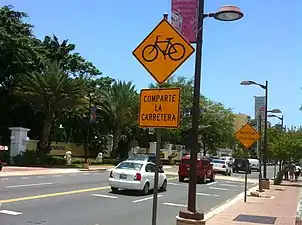
 PR-37 in Isla Verde
 Calle Loíza (PR-37) in San Juan after Hurricane Maria (2017)
Major intersections
| Municipality | Location | km[1] | mi | Destinations | Notes |
|---|---|---|---|---|---|
| San Juan | Santurce | 0.0 | 0.0 | Western terminus of PR-37; one-way street | |
| 0.2 | 0.12 | One-way street | |||
| 0.7 | 0.43 | PR-26 exit 2B; diamond interchange | |||
| 1.0– 1.1 | 0.62– 0.68 | PR-Avenida José de Diego / PR-Avenida Wilson / PR-Calle Loíza – Santurce | Northern terminus of PR-37 through Avenida José de Diego; western terminus of PR-37 through Calle Loíza | ||
| 1.3 | 0.81 | PR-Calle San Jorge / PR-Kings Court – Santurce | |||
| Carolina | Cangrejo Arriba | 4.6 | 2.9 | ||
| 6.8 | 4.2 | Eastern terminus of PR-37 | |||
1.000 mi = 1.609 km; 1.000 km = 0.621 mi
| |||||
See also
References
- 1 2 Google (28 February 2020). "PR-37" (Map). Google Maps. Google. Retrieved 28 February 2020.
- ↑ Puerto Rico Department of Transportation and Public Works. "Datos de Transito 2000-2009" (in Spanish). Archived from the original on 1 April 2019. Retrieved 29 March 2019.
- ↑ National Geographic Maps (2011). Puerto Rico (Map). 1:125,000. Adventure Map (Book 3107). Evergreen, Colorado: National Geographic Maps. ISBN 978-1566955188. OCLC 756511572.
External links
 Media related to Puerto Rico Highway 37 at Wikimedia Commons
This article is issued from Wikipedia. The text is licensed under Creative Commons - Attribution - Sharealike. Additional terms may apply for the media files.
