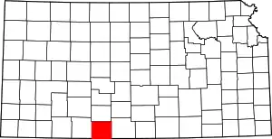
Protection Township | |
|---|---|
 Location in Comanche County | |
| Coordinates: 37°12′30″N 099°28′01″W / 37.20833°N 99.46694°W | |
| Country | United States |
| State | Kansas |
| County | Comanche |
| Area | |
| • Total | 173.56 sq mi (449.52 km2) |
| • Land | 173.07 sq mi (448.26 km2) |
| • Water | 0.49 sq mi (1.26 km2) 0.28% |
| Elevation | 1,850 ft (564 m) |
| Population (2000) | |
| • Total | 734 |
| • Density | 4.2/sq mi (1.6/km2) |
| GNIS ID | 470825 |
Protection Township is a township in Comanche County, Kansas, United States. As of the 2000 census, its population was 734.
Geography
Protection Township covers an area of 173.56 square miles (449.5 km2) and contains one incorporated settlement, Protection. According to the USGS, it contains two cemeteries: Mennonite and Protection.
The township borders Oklahoma on the south.[1]
The streams of Bluff Creek, Buzzard Creek, Cavalry Creek, Kiowa Creek, East Kiowa Creek, Middle Kiowa Creek, West Kiowa Creek, Nichols Creek, Wiggins Creek and Willow Creek run through this township. The Cimarron River traverses the southwest corner of the township, coming in from the west and curving south into Oklahoma.[2]
Transportation
Protection is crossed by US Route 183, concurrent with US Route 160 (east/west).[1]
Protection Municipal Airport was just southwest of the town of Protection, but is no longer operational.[3][4] Commercial air transportation is available out of Dodge City Regional Airport, about 58 miles to the northwest of town.[5][6]
References
- 1 2 "Protection Township, KS". Google Maps. Retrieved August 22, 2021.
- ↑ "Protection Township, KS". Google Maps. Retrieved August 22, 2021.
- ↑ "Protection Municipal Airport (historical) in Comanche County KS". HomeTownLocator. Retrieved August 22, 2021.
- ↑ "Kansas Historical Airports". HomeTownLocator. Retrieved August 22, 2021.
- ↑ "Dodge City Regional Airport". Dodge City. Retrieved August 22, 2021.
- ↑ "Dodge City Regional Airport to Protection, Kansas". Google Maps. Retrieved August 22, 2021.
External links
