| Piota | |
|---|---|
 Upper course winter view | |
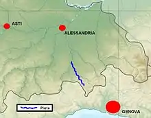
 Location within the SE Piedmont | |
| Location | |
| Country | Italy |
| Physical characteristics | |
| Source | |
| • location | Monte Pracaban |
| • elevation | 948 m (3,110 ft) |
| Mouth | |
• location | Orba at Silvano d'Orba |
• coordinates | 44°40′58″N 8°39′50″E / 44.6827°N 8.6640°E |
• elevation | 196 m (643 ft) |
| Length | 32.1 km (19.9 mi)[1] |
| Basin size | 113.34 km2 (43.76 sq mi)[1] |
| Discharge | |
| • average | 3.4 m3/s (120 cu ft/s) |
| Basin features | |
| Progression | Orba→ Bormida→ Tanaro→ Po→ Adriatic Sea |
| Tributaries | |
| • right | Gorzente |
The Piota is an Apennine torrent in the Province of Alessandria, north-west Italy.
Geography

The Piota close to its confluence in the Orba
The Piota passes through the territory of the communes of Bosio, Casaleggio Boiro, Lerma, Tagliolo Monferrato, Silvano d'Orba and Rocca Grimalda. As a tributary of the Orba, the Piota falls within the Po basin.
The river's source is on the Piedmontese flank of Monte Pracaban and its course takes it through the wild landscapes of the Ligurian Apennine that form the Parco Regionale delle Capanne di Marcarolo. Having been joined by the Gorzente, the Piota enters the Orba near Silvano d'Orba.
Fishing
Trout are fished for in the river and it is possible to pan flecks of gold.
References
- 1 2 AA.VV. (2004-07-01). "Elaborato I.c/5". Piano di Tutela delle Acque - Revisione del 1º luglio 2004; Caratterizzazione bacini idrografici (PDF). Regione Piemonte. Archived from the original (pdf) on 2012-02-25. Retrieved 2010-04-02.
![]() Media related to Piota at Wikimedia Commons
Media related to Piota at Wikimedia Commons
This article is issued from Wikipedia. The text is licensed under Creative Commons - Attribution - Sharealike. Additional terms may apply for the media files.