Phan
พาน | |
|---|---|
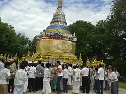
 Local people gathering at Wat Phra Thart Chom Chaeng to make merit | |
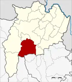
 District location in Chiang Rai province | |
| Coordinates: 19°33′14″N 99°44′26″E / 19.55389°N 99.74056°E | |
| Country | Thailand |
| Province | Chiang Rai |
| Seat | Mueang Phan |
| Area | |
| • Total | 1,023.0 km2 (395.0 sq mi) |
| Population (2005) | |
| • Total | 128,143 |
| • Density | 125.3/km2 (325/sq mi) |
| Time zone | UTC+7 (ICT) |
| Postal code | 57120 |
| Geocode | 5705 |
Phan (Thai: พาน; IPA: [pʰāːn]) is a district (amphoe) in the southern part of Chiang Rai province, northern Thailand.
Geography
Neighboring districts are (from the south west clockwise): Wiang Pa Pao, Mae Suai, Mae Lao, Mueang Chiang Rai, and Pa Daet of Chiang Rai Province; Mae Chai of Phayao province; and Wang Nuea of Lampang province.
The mountains of the Phi Pan Nam Range dominate the landscape of the district.
History
Originally named Mueang Phan, it was renamed Phan in 1938, as the word mueang was then reserved for the capital districts of the provinces.[1]
Administration
Central administration
The district Phan is subdivided into 15 subdistricts (Tambon), which are further subdivided into 236 administrative villages (Muban).
| No. | Name | Thai | Villages | Pop.[2] |
|---|---|---|---|---|
| 1. | San Makhet | สันมะเค็ด | 21 | 10,206 |
| 2. | Mae O | แม่อ้อ | 20 | 9,179 |
| 3. | Than Thong | ธารทอง | 11 | 6,461 |
| 4. | Santi Suk | สันติสุข | 9 | 5,184 |
| 5. | Doi Ngam | ดอยงาม | 14 | 6,152 |
| 6. | Hua Ngom | หัวง้ม | 13 | 6,712 |
| 7. | Charoen Mueang | เจริญเมือง | 22 | 8,302 |
| 8. | Pa Hung | ป่าหุ่ง | 18 | 10,480 |
| 9. | Muang Kham | ม่วงคำ | 17 | 8,000 |
| 10. | Sai Khao | ทรายขาว | 17 | 9,667 |
| 11. | San Klang | สันกลาง | 18 | 8,609 |
| 12. | Mae Yen | แม่เย็น | 11 | 5,436 |
| 13. | Mueang Phan | เมืองพาน | 25 | 18,463 |
| 14. | Than Tawan | ทานตะวัน | 12 | 5,887 |
| 15. | Wiang Hao | เวียงห้าว | 8 | 3,355 |
Local administration
There are 2 subdistrict municipalities (Thesaban Tambon) in the district:
- Mueang Phan (Thai: เทศบาลตำบลเมืองพาน) consisting of parts of the subdistrict Mueang Phan.
- San Makhet (Thai: เทศบาลตำบลสันมะเค็ด) consisting of the complete subdistrict San Makhet.
There are 14 subdistrict administrative organizations (SAO) in the district:
- Mae O (Thai: องค์การบริหารส่วนตำบลแม่อ้อ) consisting of the complete subdistrict Mae O.
- Than Thong (Thai: องค์การบริหารส่วนตำบลธารทอง) consisting of the complete subdistrict Than Thong.
- Santi Suk (Thai: องค์การบริหารส่วนตำบลสันติสุข) consisting of the complete subdistrict Santi Suk.
- Doi Ngam (Thai: องค์การบริหารส่วนตำบลดอยงาม) consisting of the complete subdistrict Doi Ngam.
- Hua Ngom (Thai: องค์การบริหารส่วนตำบลหัวง้ม) consisting of the complete subdistrict Hua Ngom.
- Charoen Mueang (Thai: องค์การบริหารส่วนตำบลเจริญเมือง) consisting of the complete subdistrict Charoen Mueang.
- Pa Hung (Thai: องค์การบริหารส่วนตำบลป่าหุ่ง) consisting of the complete subdistrict Pa Hung.
- Muang Kham (Thai: องค์การบริหารส่วนตำบลม่วงคำ) consisting of the complete subdistrict Muang Kham.
- Sai Khao (Thai: องค์การบริหารส่วนตำบลทรายขาว) consisting of the complete subdistrict Sai Khao.
- San Klang (Thai: องค์การบริหารส่วนตำบลสันกลาง) consisting of the complete subdistrict San Klang.
- Mae Yen (Thai: องค์การบริหารส่วนตำบลแม่เย็น) consisting of the complete subdistrict Mae Yen.
- Mueang Phan (Thai: องค์การบริหารส่วนตำบลเมืองพาน) consisting of parts of the subdistrict Mueang Phan.
- Than Tawan (Thai: องค์การบริหารส่วนตำบลทานตะวัน) consisting of the complete subdistrict Than Tawan.
- Wiang Hao (Thai: องค์การบริหารส่วนตำบลเวียงห้าว) consisting of the complete subdistrict Wiang Hao.
References
- ↑ พระราชกฤษฎีกาเปลี่ยนนามจังหวัด และอำเภอบางแห่ง พุทธศักราช ๒๔๘๑ (PDF). Royal Gazette (in Thai). 55 (ก): 658–666. 14 November 1938. Archived from the original (PDF) on 8 November 2011.
- ↑ "Population statistics 2018" (in Thai). Department of Provincial Administration. Retrieved 19 June 2020.
External links
 Chiang Rai Province travel guide from Wikivoyage
- amphoe.com (Thai)