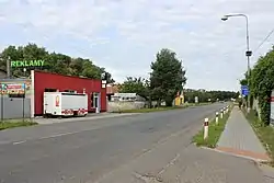
Písková Lhota | |
|---|---|
 Main road | |
 Písková Lhota Location in the Czech Republic | |
| Coordinates: 50°7′53″N 15°3′57″E / 50.13139°N 15.06583°E | |
| Country | |
| Region | Central Bohemian |
| District | Nymburk |
| First mentioned | 1553 |
| Area | |
| • Total | 6.43 km2 (2.48 sq mi) |
| Elevation | 188 m (617 ft) |
| Population (2023-01-01)[1] | |
| • Total | 523 |
| • Density | 81/km2 (210/sq mi) |
| Time zone | UTC+1 (CET) |
| • Summer (DST) | UTC+2 (CEST) |
| Postal code | 290 01 |
| Website | piskova-lhota |
Písková Lhota is a municipality and village in Nymburk District in the Central Bohemian Region of the Czech Republic. It has about 500 inhabitants.
Geography
Písková Lhota is located about 6 kilometres (4 mi) south of Nymburk and 36 km (22 mi) east of Prague. It lies in a flat agricultural landscape in the Central Elbe Table. The Výrovka River flows along the western municipal border.
There is an artificial lake called Pískovna. It was created by flooding a sandstone and gravel quarry. Today it is used for recreational purposes.[2]
History
The first written mention of Písková Lhota is from 1553.[3]
Transport
The D11 motorway (part of the European route E67) from Prague to Hradec Králové passes through the municipality.
Sights
There are no cultural monuments.[4]
References
- ↑ "Population of Municipalities – 1 January 2023". Czech Statistical Office. 2023-05-23.
- ↑ "Jezero Písková Lhota". Kamsevydat.cz (in Czech). 2016-07-07. Retrieved 2023-03-03.
- ↑ "Historie obce" (in Czech). Obec Písková Lhota. Retrieved 2023-03-03.
- ↑ "Výsledky vyhledávání: Kulturní památky, okres Nymburk". Ústřední seznam kulturních památek (in Czech). National Heritage Institute. Retrieved 2023-03-03.
External links
Wikimedia Commons has media related to Písková Lhota (Nymburk District).
This article is issued from Wikipedia. The text is licensed under Creative Commons - Attribution - Sharealike. Additional terms may apply for the media files.