Oslov | |
|---|---|
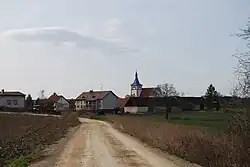
 View from the east | |
 Flag  Coat of arms | |
 Oslov Location in the Czech Republic | |
| Coordinates: 49°23′58″N 14°12′43″E / 49.39944°N 14.21194°E | |
| Country | |
| Region | South Bohemian |
| District | Písek |
| First mentioned | 1167 |
| Area | |
| • Total | 19.40 km2 (7.49 sq mi) |
| Elevation | 421 m (1,381 ft) |
| Population (2023-01-01)[1] | |
| • Total | 340 |
| • Density | 18/km2 (45/sq mi) |
| Time zone | UTC+1 (CET) |
| • Summer (DST) | UTC+2 (CEST) |
| Postal codes | 397 01, 398 35 |
| Website | www |
Oslov is a municipality and village in Písek District in the South Bohemian Region of the Czech Republic. It has about 300 inhabitants.
Administrative parts
The village of Tukleky and the hamlet of Svatá Anna are administrative parts of Oslov.
Etymology
The village was named after its founder, who was a noble named Osel. The name Osel literally means 'donkey' in Czech.[2]
Geography
Oslov is located about 11 kilometres (7 mi) north of Písek and 50 km (31 mi) north of České Budějovice. It lies in the Tábor Uplands. The highest point is at 435 metres (1,427 ft) above sea level. The municipality is situated on an elevated plateau between the Vltava and Otava rivers, on the shores of the Orlík Reservoir, which is built on both the rivers.
History
The first written mention of Oslov is from 1167, when the village was donated to the convent in Doksany.[2] Later it belonged to the Zvíkov estate.[3]
Demographics
|
|
| ||||||||||||||||||||||||||||||||||||||||||||||||||||||
| Source: Censuses[4][5] | ||||||||||||||||||||||||||||||||||||||||||||||||||||||||
Transport
The railway from Písek to Milevsko passes through the outlying part of the municipal territory, but there is no train station. The municipality is served by the train station in neighbouring Vlastec.
Sights
.jpg.webp)
The main landmark of Oslov is the Church of Saint Leonard of Noblac. Originally a Gothic church, it was first documented in 1384. It was completely rebuilt into its current form in 1788.[6]
The Červená Railway Bridge is located on the municipal border. It was built over the Orlík Reservoir in 1886–1889. It is a valuable technical monument.[7]
Notable people
- Martin Josef Říha (1839–1907), Bishop of České Budějovice
References
- ↑ "Population of Municipalities – 1 January 2023". Czech Statistical Office. 2023-05-23.
- 1 2 "Program rozvoje obce Oslov na období let 2019–2028" (in Czech). Obec Oslov. 2018-11-28. p. 3. Retrieved 2023-10-31.
- ↑ Koblihová, Stanislava (2017-03-28). "Oslov bude slavit 850. výročí obce a 160 let od otevření školy" (in Czech). Písecký deník. Retrieved 2023-10-31.
- ↑ "Historický lexikon obcí České republiky 1869–2011 – Okres Písek" (in Czech). Czech Statistical Office. 2015-12-21. pp. 15–16.
- ↑ "Population Census 2021: Population by sex". Public Database. Czech Statistical Office. 2021-03-27.
- ↑ "Kostel sv. Linharta" (in Czech). National Heritage Institute. Retrieved 2023-10-31.
- ↑ "Železniční most" (in Czech). National Heritage Institute. Retrieved 2023-10-31.