Orhionmwon
Orhionmwon Igue | |
|---|---|
| Nickname: Igue edo | |
| Country | |
| State | Edo State |
| Area | |
| • Total | 920 sq mi (2,382 km2) |
| Time zone | UTC+1 (WAT) |
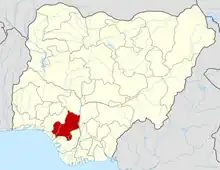
Orhionmwon is a Local Government Area of Edo State, Nigeria. Its headquarter is in the town of Abudu.[1] It has an area of 2,382 km² and a population of 206,717 at the 2006 census. The postal code of the area is 301.[2]
Orhionmwon local government area of Edo State is considered one of the biggest local government area among those in Benin City.[3] It comprises towns and communities such as Idumodin, Ottah, Okuor, Edummungba, Egbhuru, Egbokor, Ute - Oheze, Ugo, Urhonigbe, Igbanke, Iru egbede, Evbobanosa, Oza, Ogan, Uson, Oloten, Obagie N’Oheze, Idumiru, Idumwebo, Numagbae, Ugokoniro, Ukpato, Avbiugo, Okogbo, Evbuehia, Iguere, Igbekhue, iguehanza, Obozogbe-niro, Evbomede and Obi, among others.[4] The local government came about as an aftermath in the creation of the defunct Bendel State.[5] The local government has rubber plantations, agricultural produces, crude oil as well as mineral resources. Furthermore, the local government is dominated by Benin speaking communities such as Ugo and Okogbo and surrounded by neighboring Delta State (Agbor and Eku).
References
- ↑ "Concern over Orhionmwon Local Govt | The Nation Newspaper". 2013-11-01. Retrieved 2023-01-24.
- ↑ "Post Offices- with map of LGA". NIPOST. Archived from the original on October 7, 2009. Retrieved 2009-10-20.
- ↑ "Concern over Orhionmwon Local Govt | The Nation Newspaper". 2013-11-01. Retrieved 2023-01-24.
- ↑ "List of Towns and Villages in Orhionwon LGA". Nigeria Zip Codes. 2014-03-10. Retrieved 2023-05-02.
- ↑ "Concern over Orhionmwon Local Govt | The Nation Newspaper". 2013-11-01. Retrieved 2023-01-24.
