Oost-Graftdijk | |
|---|---|
Village | |
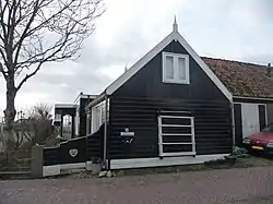
 House in Oost-Graftdijk | |
 Oost-Graftdijk Location in the Netherlands  Oost-Graftdijk Location in the province of North Holland in the Netherlands | |
| Coordinates: 52°33′N 4°49′E / 52.550°N 4.817°E | |
| Country | Netherlands |
| Province | North Holland |
| Municipality | Alkmaar |
| Area | |
| • Total | 1.38 km2 (0.53 sq mi) |
| Elevation | −1.5 m (−4.9 ft) |
| Population (2021)[1] | |
| • Total | 145 |
| • Density | 110/km2 (270/sq mi) |
| Time zone | UTC+1 (CET) |
| • Summer (DST) | UTC+2 (CEST) |
| Postal code | 1487[1] |
| Dialing code | 072 |
Oost-Graftdijk is a village in the Dutch province of North Holland. It is a part of the municipality of Alkmaar, and lies about 11 km west of Purmerend.
History
The village was first mentioned in 1639 as Oostbuert. The current name means "eastern dike of the (de Vuile) Graft (river)". Oost- (east) has been added to distinguish from West-Graftdijk.[3][4] Oost-Graftdijk is a dike village which developed in the second half of the 16th century. Around 1870, a basic Mennonite church was built in Oost-Graftdijk.[5]
Gallery
 Mennonite church
 House in Oost-Graftdijk
 Dutch Reformed church
 House in Oost-Graftdijk
References
- 1 2 3 "Kerncijfers wijken en buurten 2021". Central Bureau of Statistics. Retrieved 28 April 2022.
- ↑ "Postcodetool for 1487MA". Actueel Hoogtebestand Nederland (in Dutch). Het Waterschapshuis. Retrieved 28 April 2022.
- ↑ "Oost-Graftdijk - (geografische naam)". Etymologiebank (in Dutch). Retrieved 28 April 2022.
- ↑ "West-Graftdijk - (geografische naam)". Etymologiebank (in Dutch). Retrieved 28 April 2022.
- ↑ Ronald Stenvert & Saskia van Ginkel-Meester (2006). "West-Graftdijk" (in Dutch). Zwolle: Waanders. p. 525. Retrieved 27 April 2022.
This article is issued from Wikipedia. The text is licensed under Creative Commons - Attribution - Sharealike. Additional terms may apply for the media files.