Netterden | |
|---|---|
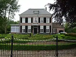
 Walburgisplein 4 | |
 Coat of arms | |
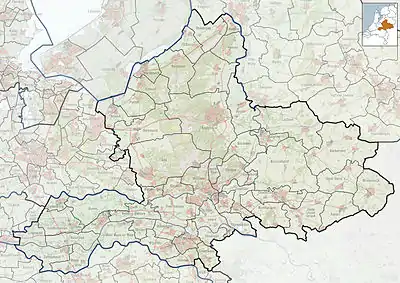
 Netterden Location in the Netherlands  Netterden Netterden (Netherlands) | |
| Coordinates: 51°51′16″N 6°18′51″E / 51.85444°N 6.31417°E | |
| Country | Netherlands |
| Province | Gelderland |
| Municipality | Oude IJsselstreek |
| Area | |
| • Total | 9.45 km2 (3.65 sq mi) |
| Elevation | 15 m (49 ft) |
| Population (2021)[1] | |
| • Total | 575 |
| • Density | 61/km2 (160/sq mi) |
| Time zone | UTC+1 (CET) |
| • Summer (DST) | UTC+2 (CEST) |
| Postal code | 7077[1] |
| Dialing code | 0315 |
| Website | netterden.nl |
Netterden is a village in the Dutch province of Gelderland. It is located in the municipality of Oude IJsselstreek, about 5 km northeast of Emmerich am Rhein in Germany.
Netterden was a separate municipality until 1821, when it was merged with Bergh.[3] The village has a border crossing to Emmerich am Rhein. The Netterdenscher Kanal is the border canal separating both countries.
History
It was first mentioned in 1218 as Netterthen. The etymology is unclear. The village of Nütterden is just across the border.[4] In 1840, it was home to 350 people.[5] In 2011, a little Lady chapel appeared in Netterden. It is unclear who made and placed it there.[6]
Gallery
 Church: de Sint Walburgiskerk
 Walburgisplein 3
 St. Walburgis
 Emmerikseweg 2
 Emmerikseweg 4
 Netterdenscher Kanal
 Border canal
References
- 1 2 3 "Kerncijfers wijken en buurten 2021". Central Bureau of Statistics. Retrieved 24 March 2022.
two entries
- ↑ "Postcodetool for 7077AA". Actueel Hoogtebestand Nederland (in Dutch). Het Waterschapshuis. Retrieved 24 March 2022.
- ↑ Ad van der Meer and Onno Boonstra, Repertorium van Nederlandse gemeenten, KNAW, 2011.
- ↑ "Netterden - (geografische naam)". Etymologiebank (in Dutch). Retrieved 24 March 2022.
- ↑ "Netterden". Plaatsengids (in Dutch). Retrieved 24 March 2022.
- ↑ "Raadsels rond kapelletje in Netterden". Gelderlander (in Dutch). 6 May 2011. Retrieved 24 March 2022.
This article is issued from Wikipedia. The text is licensed under Creative Commons - Attribution - Sharealike. Additional terms may apply for the media files.