| Morris Island Conservation Area | |
|---|---|
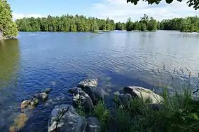
 The lagoon, Morris Island CA | |
 Location within Ontario | |
| Location | Ottawa, Ontario, Canada |
| Nearest city | Ottawa |
| Coordinates | 45°27′33″N 76°16′17″W / 45.45918°N 76.27138°W[1] |
| Area | 47 hectares (120 acres) |
| mvc | |
The Morris Island Conservation Area is operated by the Mississippi Valley Conservation Authority.[2]
Located on the Ottawa River near Fitzroy Harbour, the Morris Island Conservation Area consists of 47 hectares of forested woodlands and wetlands. It allows for hiking, picnicking, canoeing (within the bay areas of the island), and fishing (including accessible fishing platforms).[3]
References
- ↑ "Morris Island Conservation Area". Conservation Ontario. Retrieved 2016-10-16.
- ↑ Your Guide to Conservation Areas In Ontario (PDF). Conservation Ontario. 2011. p. 49.
- ↑ "Morris Island Conservation Area". Mississippi Valley Conservation Authority. Retrieved 2013-08-18.
External links
Wikimedia Commons has media related to Morris Island Conservation Area.
This article is issued from Wikipedia. The text is licensed under Creative Commons - Attribution - Sharealike. Additional terms may apply for the media files.