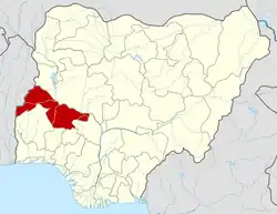
Moro | |
|---|---|
| Country | |
| State | Kwara State |
| Time zone | UTC+1 (WAT) |
Moro is a Local Government Area in Kwara State, Nigeria. It has an area of 3,272 km2 and a population of 108,792 at the 2006 census.
The postal code of the area is 241.[1]
Climate
The climate in Moro is tropical savanna. Every month is warm and there is both a wet and dry season. There is approximately 1302 mm of rain every year in Moro, and the average annual temperature is 34 degrees. With an average humidity of 70% and a UV-index of 7, there are 88 dry days per year.[2][3]
Bridge Rehabilitation
On the 8th of November 2016, the Kwara state government began the repair of the bridge that connects the state with Oyo state.[4]
School in moro
Bartholomew college of health technology shao Moro local government. A private college of health technology.[5]
Empowerment of woman
The woman of the Moro rural are is empowered with 10000 each to boost there petty trade in other to enhance/improved the economy of the area.[7]
References
- ↑ "Post Offices- with map of LGA". NIPOST. Archived from the original on 2009-10-07. Retrieved 2009-10-20.
- ↑ "Moro weather and climate ☀️ Best time to visit 🌡️ Temperature". www.besttimetovisit.com.pk. Retrieved 2023-09-30.
- ↑ "Moro, Kwara, Nigeria 10-Day Weather Forecast - The Weather Channel | Weather.com". The Weather Channel. Retrieved 2023-09-30.
- ↑ www.premiumtimesng.com https://www.premiumtimesng.com/regional/north-central/214768-kwara-begins-repair-collapsed-moro-bridge.html?tztc=1. Retrieved 2023-10-22.
{{cite web}}: Missing or empty|title=(help) - ↑ "Private Colleges of Health | National Board for Technical Education". net.nbte.gov.ng. Retrieved 2023-10-22.
- ↑ "Official List of Courses Offered in Bartholomew College of Health Technology (BACOHTECH) - Myschool". myschool.ng. Retrieved 2023-10-22.
- ↑ Dangote; M, Content (2021-04-01). "Dangote Empowers 16,000 Rural Women in all Kwara Local Government Areas". Dangote Industries Limited. Retrieved 2023-10-22.
