| Moelwyn Bach | |
|---|---|
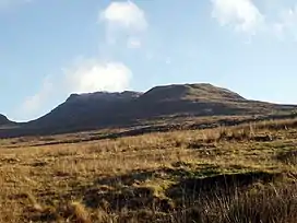
 Moelwyn Bach from the west | |
| Highest point | |
| Elevation | 712 m (2,336 ft) |
| Prominence | 127 m (417 ft) |
| Listing | Hewitt, Nuttall, HuMP |
| Naming | |
| English translation | little white hill |
| Language of name | Welsh |
| Pronunciation | Welsh: [ˈmɔɨlwɨn ˈbaːx] |
| Geography | |
| Location | Gwynedd, Wales |
| Parent range | Snowdonia |
| OS grid | SH660437 |
| Topo map | OS Landranger 124 |
Moelwyn Bach is a mountain in Snowdonia, northern Wales and forms part of the Moelwynion. It is connected to its parent peak Moelwyn Mawr via the Craigysgafn ridge.
It overlooks the town of Blaenau Ffestiniog and the Vale of Ffestiniog.[1]
References
External links
52°58′26″N 3°59′49″W / 52.97385°N 3.99701°W
This article is issued from Wikipedia. The text is licensed under Creative Commons - Attribution - Sharealike. Additional terms may apply for the media files.