36°07′30″N 5°20′35″W / 36.125034°N 5.343172°W
| Mediterranean Steps | |
|---|---|
 The steps were refurbished and made safe in 2007 | |
| Location | Upper Rock Nature Reserve, Gibraltar |
| Designation | Nature Trail |
| Highest point | Lord Airey's Battery, 400 m (1,300 ft) |
| Season | All year - £16.00 entry [1] |
| Sights | Levant Battery, Martin's Cave, Goat's Hair Twin Caves, Lord Airey's Battery, Strait of Gibraltar |
| Hazards | lack of water, vertigo, worn path |
| Trail map | |
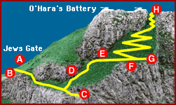
 A.Jews Gate B.Levant Battery C.Martin's Cave D.Goat's Hair Twin Caves E.Tunnel and Pumping Station F.WW2 Observation Posts G.View point H.Lord Airey's Battery Top of Steps | |
Mediterranean Steps is a path and nature trail in the British Overseas Territory of Gibraltar. One of the footpaths of Gibraltar, the path is located entirely within the Upper Rock Nature Reserve and was built by the British military but is now used by civilians as a pedestrian route linking Martin's Path to Lord Airey's Battery near the summit of Rock of Gibraltar. The path offers views over the Strait of Gibraltar, Windmill Hill, Europa Point, the Great Sand Dune, Gibraltar's east side beaches, the Mediterranean Sea and the Spanish Costa del Sol.
History
.jpg.webp)

The Mediterranean Steps were built as part of the military communications system built by the British to allow access to their various defence posts[2] at the southern end of the Rock. At the highest point of the steps are the two 9.2 inch guns of Lord Airey's Battery and O'Hara's Battery. Other gun emplacements and ancillary buildings dating back to World War II are evident along the route.[3]
The steps were restored in 2007[3] by the Bonita Trust, the Government of Gibraltar and the Gibraltar Ornithological and Natural History Society.[2]
Route
The steps zig-zag up the Rock from the end of Martin's Path to near the summit. Martin's Path starts on the south western slopes of the Rock gently above the derelict Levant Battery near Jews' Gate Cemetery and proceeds to its first bend as the path turns to the east side of the Rock where it joins Mediterranean Steps. Martin's Path actually continues onwards to Martin's Cave but the way is prohibited and a locked gate protects the cave.[3][4]
The route is entirely within the Upper Rock Nature Reserve and the Goat's Hair Twin Caves can be seen on the way. These caves show evidence of when they were sea caves and the level of the sea was dramatically higher. These are amongst a number of caves in Gibraltar which have given evidence of prehistoric human habitation.
The path leads up to a derelict pre-war tunnel and pumping station, once an operational old fresh water pumping station which collected rain water via the geologically modified slopes above. These slopes extend towards the top of the Rock (O'Hara's battery).[5] The trail continues on a short path to a viewing platform and continues up the Rock to the twin batteries on the Rock's upper ridge.[3] The path emerges at what was the location of O'Hara's Tower (O'Hara's Folly)[6] which was a watchtower built in an attempt to observe shipping in the port of Cádiz. It proved to be useless and lightning eventually created a ruin that was later destroyed in target practice.
References
- This article contains text from Discover-Gibraltar.com
- ↑ "Admission Prices". Visit Gibraltar. Retrieved 24 October 2022.
- 1 2 "Mediterranean Steps". bonitatrust.org. Archived from the original on 15 June 2008. Retrieved 12 June 2013.
- 1 2 3 4 Crone, Jim. "Mediterranean Steps (see index)". Discover-Gibraltar.com. Archived from the original on 5 September 2013. Retrieved 9 June 2013.
- ↑ 1961 Military Map of Gibraltar
- ↑ "Rock Ramblers". RockRamblers. Retrieved 21 April 2018.
- ↑ Robertson, William (1865). Journal of a clergyman during a visit to the Peninsula. p. 147.
External links
 Media related to Mediterranean Steps at Wikimedia Commons