Mantamados
Μανταμάδος | |
|---|---|
 | |
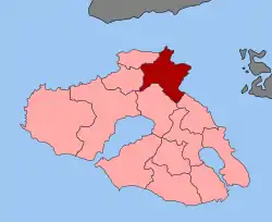
 Mantamados Location within the regional unit  | |
| Coordinates: 39°16′N 26°20′E / 39.267°N 26.333°E | |
| Country | Greece |
| Administrative region | North Aegean |
| Regional unit | Lesbos |
| Municipality | West Lesbos |
| • Municipal unit | 122.4 km2 (47.3 sq mi) |
| Population (2011)[1] | |
| • Municipal unit | 2,447 |
| • Municipal unit density | 20/km2 (52/sq mi) |
| Community | |
| • Population | 1,172 (2011) |
| Time zone | UTC+2 (EET) |
| • Summer (DST) | UTC+3 (EEST) |
| Vehicle registration | MY |
Mantamados (Greek: Μανταμάδος/Mantamaðos) is a town and a former municipality on the island of Lesbos, North Aegean, Greece. Since the 2019 local government reform it is part of the municipality of West Lesbos, of which it is a municipal unit.[2] It is located at the northeast corner of the island, and has a land area of 122.435 km².[3] Its population was 2,447 at the 2011 census. The municipal seat was the town of Mantamádos (pop. 941). Its largest other towns are Kápi (544), Kleió (356), and Pelópi (351).
Mantamados is very famous for the monastery of the Archangel Michael of Mantamados, popular among the believers of Greece, on the outskirts of the village. The island is also famous for its cheese (Ladotyri Mytilinis) and for its farms. It was also one of the few places in Greece to have a mayor belonging to the Communist Party of Greece until 2000.
References
- 1 2 "Απογραφή Πληθυσμού - Κατοικιών 2011. ΜΟΝΙΜΟΣ Πληθυσμός" (in Greek). Hellenic Statistical Authority.
- ↑ "Τροποποίηση του άρθρου 1 του ν. 3852/2010" [Amendment of Article 1 of l. 3852/2010] (in Greek). Government Gazette. p. 1164.
- ↑ "Population & housing census 2001 (incl. area and average elevation)" (PDF) (in Greek). National Statistical Service of Greece. Archived from the original (PDF) on 2015-09-21.
External links
![]() Media related to Mantamados at Wikimedia Commons
Media related to Mantamados at Wikimedia Commons
- Official website (in Greek)