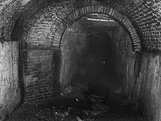
Alcantarilla Pluvial sobre la Quebrada Manzanares | |
 | |
| Location | Extending from approximately the junction of Ferrocarril and Esperanza Streets to approximately the junction of Javilla and Ensanche Streets[lower-alpha 1] San German, Puerto Rico |
|---|---|
| Coordinates | 18°04′54″N 67°02′33″W / 18.081531°N 67.042515°W |
| Area | 0.5 acres (0.20 ha) |
| Built | 1835 |
| Part of | San Germán Historic District[1] (ID94000084) |
| NRHP reference No. | 90000552[2] |
| Added to NRHP | April 12, 1990 |
The San Germán Underground (Spanish: Túneles subterráneos de San Germán) is a vaulted brick storm sewer system built in 1835 underneath the urban center of San Germán, Puerto Rico. The system is made of a central tunnel and several smaller side tunnels. The construction is of brick and rubble with modern concrete repairs. The main part of the system covers the underground course of Quebrada Manzanares from its headwaters to its resurgence as a surface stream, 842.53 metres (2,764.2 ft) away.[3] The vaulted brick branches, most of them abandoned and sealed, date mostly from before 1910. The tunnel sections built up to 1918 are listed on the National Register of Historic Places as Alcantarilla Pluvial sobre la Quebrada Manzanares.
See also
Notes
- ↑ The Alcantarilla Pluvial sobre la Quebrada Manzanares is a linear resource; the coordinates given represent the approximate midpoint of the line.
References
- ↑ González Mendoza, Juan R.; Vega Lubo, Ramonita; García Goyco, Osvaldo; Maza, Doris (September 1993), National Register of Historic Places Registration Form: San Germán Historic District (PDF), retrieved February 2, 2016.
- ↑ "National Register Information System". National Register of Historic Places. National Park Service. March 13, 2009.
- ↑ "Nomination form". National Park Service. Retrieved 27 February 2010.
External links
- National Park Service images
- Los Tuneles.Information from the city of San Germán (Spanish)
This article is issued from Wikipedia. The text is licensed under Creative Commons - Attribution - Sharealike. Additional terms may apply for the media files.