| Loch Voil | |
|---|---|
.jpg.webp) View from Creag An Tuirc | |
 Loch Voil | |
| Location | Perthshire, Scotland |
| Coordinates | 56°20′53″N 4°25′19″W / 56.348000°N 4.422°W |
| Type | freshwater loch |
| Primary inflows | River Larig |
| River sources | River Balvaig |
| Max. length | 5.6 km (3.5 mi)[1] |
| Max. width | 0.4 km (0.25 mi)[1] |
| Surface area | 216.6 ha (535 acres)[2] |
| Average depth | 39.5 ft (12.0 m)[1] |
| Max. depth | 98 ft (30 m)[1] |
| Shore length1 | 13.5 km (8.4 mi) [2] |
| Surface elevation | 127 m (417 ft)[2] |
| Islands | 1 |
| 1 Shore length is not a well-defined measure. | |
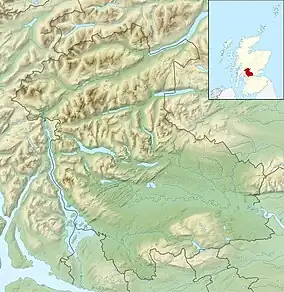
Loch Voil (Scottish Gaelic: Loch a' Bheothail)[3] is a small freshwater loch that lies to the west of Balquhidder in the Stirling council area of Scotland. It is a short, narrow loch. It is separated from Loch Doine by fluvial deposits from the Monachyle Burn and is drained at its eastern end by the River Balvag at Balquhidder. The Loch can be reached by a small single track road from Balquhidder leading to Inverlochlarig.[1][2]
References
- 1 2 3 4 5 John, Murray; Lawrence, Pullar (1910). Bathymetrical Survey of the Fresh-Water Lochs of Scotland, 1897-1909 Lochs of the Forth Basin Volume II - Loch Voil. National Library of Scotland: National Challenger Officer. p. 10. Retrieved 12 January 2018.
 This article incorporates text from this source, which is in the public domain.
 - 1 2 3 4 "Loch Voil". British Lakes. Retrieved 8 May 2018.
- ↑ "Gaelic Place-Names of Scotland database". Ainmean-Àite na h-Alba. Retrieved 1 June 2017.
Wikimedia Commons has media related to Loch Voil.
This article is issued from Wikipedia. The text is licensed under Creative Commons - Attribution - Sharealike. Additional terms may apply for the media files.