Coat of arms
Liebenwerda is a Verbandsgemeinde ("collective municipality") in the district of Elbe-Elster, in Brandenburg, Germany. Its seat is in Bad Liebenwerda. It was established in January 2020.
The Verbandsgemeinde Liebenwerda consists of the following municipalities:
Demography
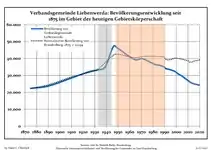
 Development of Population since 1875 within the Current Boundaries (Blue Line: Population; Dotted Line: Comparison to Population Development of Brandenburg state; Grey Background: Time of Nazi rule; Red Background: Time of Communist rule)
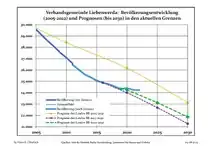
 Recent Population Development and Projections (Population Development before Census 2011 (blue line); Recent Population Development according to the Census in Germany in 2011 (blue bordered line); Official projections for 2005-2030 (yellow line); for 2017-2030 (scarlet line); for 2020-2030 (green line)
|
|
|
References
- ↑ Detailed data sources are to be found in the Wikimedia Commons.Population Projection Brandenburg at Wikimedia Commons
51°30′57″N 13°23′32″E / 51.515944°N 13.392227°E
This article is issued from Wikipedia. The text is licensed under Creative Commons - Attribution - Sharealike. Additional terms may apply for the media files.