Libouchec | |
|---|---|
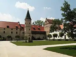
 Libouchec Castle | |
 Flag  Coat of arms | |
 Libouchec Location in the Czech Republic | |
| Coordinates: 50°45′31″N 14°2′27″E / 50.75861°N 14.04083°E | |
| Country | |
| Region | Ústí nad Labem |
| District | Ústí nad Labem |
| First mentioned | 1169 |
| Area | |
| • Total | 28.02 km2 (10.82 sq mi) |
| Elevation | 336 m (1,102 ft) |
| Population (2023-01-01)[1] | |
| • Total | 1,895 |
| • Density | 68/km2 (180/sq mi) |
| Time zone | UTC+1 (CET) |
| • Summer (DST) | UTC+2 (CEST) |
| Postal codes | 400 02, 403 35 |
| Website | www |
Libouchec (German: Königswald) is a municipality and village in Ústí nad Labem District in the Ústí nad Labem Region of the Czech Republic. It has about 1,900 inhabitants.
Administrative parts
Villages of Čermná, Knínice, and Žďárek are administrative parts of Libouchec.
Geography
Libouchec is located about 9 kilometres (6 mi) north of Ústí nad Labem. The municipal territory is very diverse and lies in fourth nature regions. The built-up area is situated in the valley of the Jílovský brook, which is part of the Most Basin lowland. The valley separates the Central Bohemian Uplands and the eastern tip of the Ore Mountains. The northeastern part of the municipality extends into the Elbe Sandstone Mountains and includes the highest point of the municipality, Nad Stěnami at 623 m (2,044 ft) above sea level.
History
The first settlers of the area were Celts and Germanics, from the 5th century initially mainly Slavs and from the late Middle Ages onwards mainly Germans. The first written mention of Libouchec is from 1169 under its German name Königswald. Libouchec gained its Czech name after the eponymous stream.[2]
An important salt trail was running through Libouchec. Salt was carried from here to Děčín where it was embarked and sent to inland. There started an important production in manufacture in the end of feudalism (buttons, textile, primitive machines). In the 16th century, the nobility from Bynov began with logging and mining of ore and silver. In the 19th century its surroundings were an industrial region. There began the production of velvet, liqueurs, mustard and agricultural machines.[2]
Important was the railway which led from Duchcov to Děčín. It was built in 1869 and was the most expensive railway in the country being built at that time.[2] The operation of this railway was abolished in 2008.
Demographics
|
|
| ||||||||||||||||||||||||||||||||||||||||||||||||||||||
| Source: Censuses[3][4] | ||||||||||||||||||||||||||||||||||||||||||||||||||||||||
Tranport
During the tourist season, on weekends and holidays, a train on the Děčín–Telnice line runs through Libouchec. The ČSD Class M 152.0 retro train drives there.[5]
Sights

The most significant buildings are the Church of Three Wise Men and the castle. The church was built in 1357; after burning out it was repaired in the 16th century and from that time it has been rebuilt many times.[2]
The Libouchec Castle, originally named Schönstein, was established by Günter of Bünau in the 16th century. Due to the Thirty Years' War and fires, the castle gradually fell into disrepair and it has been in the emergency conditions. In 2003, the castle was sold and has since been repaired.[2][6]
References
- ↑ "Population of Municipalities – 1 January 2023". Czech Statistical Office. 2023-05-23.
- 1 2 3 4 5 "Historie – Libouchec" (in Czech). Obec Libouchec. Retrieved 2021-07-10.
- ↑ "Historický lexikon obcí České republiky 1869–2011 – Okres Ústí nad Labem" (in Czech). Czech Statistical Office. 2015-12-21. pp. 3–4.
- ↑ "Population Census 2021: Population by sex". Public Database. Czech Statistical Office. 2021-03-27.
- ↑ "Podkrušnohorský motoráček na Kozí dráze" (in Czech). CzechTourism. Retrieved 2023-06-12.
- ↑ "Architektonický vývoj panského dvora (nové tvrze, zámku) v Libouchci" (in Czech). Libouchec Castle. Retrieved 2021-07-10.