Košice-South
Košice-Juh | |
|---|---|
Borough | |
 Košice-Juh | |
 Flag  Coat of arms | |
 Location within Košice | |
| Country | Slovakia |
| Region | Košice |
| District | Košice IV |
| Area | |
| • Total | 9.77 km2 (3.77 sq mi) |
| Elevation | 200 m (700 ft) |
| Population (31 December 2017) | |
| • Total | 23,030 |
| • Density | 2,400/km2 (6,100/sq mi) |
| Postal code | 040 11 |
| Area code | +421-55 |
| Car plate | KE |
| Website | www.kosicejuh.sk |
| Source [1] | |
Košice-Juh (literally: Košice-South; Hungarian: Kassa-Dél) is a borough (city ward) of the city of Košice, Slovakia. Located in the Košice IV district, in the southern area of the city, it lies at an altitude of roughly 200 metres (660 ft) above sea level.
Historical landmarks
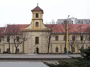
The oldest building in the borough is the Holy Spirit Church, erected in 1733.
Statistics
- Area: 9.77 square kilometres (3.77 sq mi)
- Population: 23,030 (31 December 2017)
- Density of population: 2,400/km² (31 December 2017)
- District: Košice IV
- Mayor: Jaroslav Hlinka (as of 2018 elections)
Gallery
 18th century Holy Spirit Church, the oldest building in the borough
.jpg.webp) Kasárne-Kulturpark (Art and culture centre converted from historical barracks)
Kasárne-Kulturpark (Art and culture centre converted from historical barracks).jpg.webp) Kasárne-Kulturpark (Art and culture centre converted from historical barracks)
Kasárne-Kulturpark (Art and culture centre converted from historical barracks) Local church in the Košice-Juh borough
 Local post office in the Košice-Juh borough
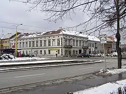
 Inn in an older building at the corner of a street
 Apartment blocks at a Košice-Juh housing estate
 Business center Moldavská
 Cassovia Shopping Center
Climate
| Climate data for Kosice | |||||||||||||
|---|---|---|---|---|---|---|---|---|---|---|---|---|---|
| Month | Jan | Feb | Mar | Apr | May | Jun | Jul | Aug | Sep | Oct | Nov | Dec | Year |
| Mean daily maximum °C (°F) | −1 (31) |
2 (36) |
8 (47) |
14 (57) |
19 (66) |
22 (71) |
24 (75) |
23 (74) |
19 (67) |
13 (56) |
5 (41) |
1 (33) |
13 (55) |
| Mean daily minimum °C (°F) | −5 (23) |
−3 (26) |
1 (33) |
5 (41) |
9 (49) |
12 (54) |
14 (57) |
13 (56) |
10 (50) |
6 (42) |
0 (32) |
−3 (26) |
5 (41) |
| Average precipitation mm (inches) | 28 (1.1) |
30 (1.2) |
30 (1.2) |
36 (1.4) |
66 (2.6) |
86 (3.4) |
86 (3.4) |
79 (3.1) |
51 (2) |
36 (1.4) |
46 (1.8) |
38 (1.5) |
620 (24.3) |
| Source: Weatherbase [2] | |||||||||||||
References
- ↑ Mestská a obecná štatistika SR (urgently needs an updated statistics link for 2018) Archived 2007-04-27 at the Wayback Machine
- ↑ "Weatherbase: Historical Weather for Kosice, Slovakia". Weatherbase. 2011. Retrieved on November 24, 2011.
External links
Wikimedia Commons has media related to Košice-Juh.
- Official website of the Košice-Juh borough
- Article on the Košice-Juh borough at Cassovia.sk
- Official website of Košice
48°42′33″N 21°15′25″E / 48.70917°N 21.25694°E
This article is issued from Wikipedia. The text is licensed under Creative Commons - Attribution - Sharealike. Additional terms may apply for the media files.