Kirribilli | ||||||||||||
|---|---|---|---|---|---|---|---|---|---|---|---|---|
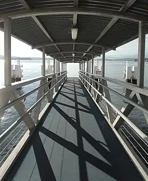
 Gangplank in April 2014 | ||||||||||||
| General information | ||||||||||||
| Location | Holbrook Avenue, Kirribilli New South Wales Australia | |||||||||||
| Coordinates | 33°50′57.79″S 151°13′12.96″E / 33.8493861°S 151.2202667°E | |||||||||||
| Owned by | Transport for NSW | |||||||||||
| Operated by | Transdev Sydney Ferries | |||||||||||
| Platforms | 1 wharf (1 berth) | |||||||||||
| Connections | ||||||||||||
| Construction | ||||||||||||
| Accessible | Yes | |||||||||||
| Other information | ||||||||||||
| Status | Unstaffed | |||||||||||
| History | ||||||||||||
| Previous names | North Sydney, Kirribilli (–2002) | |||||||||||
| Services | ||||||||||||
| ||||||||||||
Kirribilli ferry wharf is located on the northern side of Sydney Harbour serving the Sydney suburb of Kirribilli. It is served by Sydney Ferries Neutral Bay services operating between Circular Quay and Neutral Bay.[1] The single wharf is served by First Fleet class ferries.
Wharves and services
| Platform | Line | Stopping pattern | Notes |
| 1 | Circular Quay to Neutral Bay | [1] |
|---|
Connections
Busways operates one bus route via Kirribilli wharf, under contract to Transport for NSW:
- 269: to McMahons Point wharf[2]
References
- 1 2 "F5 Neutral Bay ferry timetable". Transport for NSW.
- ↑ "State Transit route 269". Transport for NSW.
External links
 Media related to Kirribilli ferry wharf, Sydney at Wikimedia Commons
- Kirribilli Wharf at Transport for New South Wales (Archived 12 June 2019)
- Kirribilli Local Area Map Transport for NSW
This article is issued from Wikipedia. The text is licensed under Creative Commons - Attribution - Sharealike. Additional terms may apply for the media files.