Kiischpelt
Kiischpelt | |
|---|---|
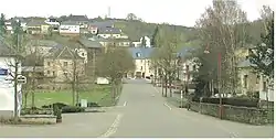
 Wilwerwiltz | |
.png.webp) Coat of arms | |
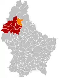
 Map of Luxembourg with Kiischpelt highlighted in orange, and the canton in dark red | |
| Coordinates: 49°59′31″N 6°00′22″E / 49.9919°N 6.0061°E | |
| Country | |
| Canton | Wiltz |
| Area | |
| • Total | 33.58 km2 (12.97 sq mi) |
| • Rank | 20th of 102 |
| Highest elevation | 498 m (1,634 ft) |
| • Rank | 19th of 102 |
| Lowest elevation | 241 m (791 ft) |
| • Rank | 47th of 102 |
| Population (2023) | |
| • Total | 1,260 |
| • Rank | 97th of 102 |
| • Density | 38/km2 (97/sq mi) |
| • Rank | 102nd of 102 |
| Time zone | UTC+1 (CET) |
| • Summer (DST) | UTC+2 (CEST) |
| LAU 2 | LU0000805 |
| Website | kiischpelt.lu |
Kiischpelt is a commune in northern Luxembourg, in the canton of Wiltz. The commune's administrative centre is Wilwerwiltz.
Kiischpelt was formed on 1 January 2006 from the former communes of Kautenbach and Wilwerwiltz, both in Wiltz canton. The law creating Kiischpelt was passed on 14 July 2005.[1]
It is the least densely populated commune in Luxembourg.
Populated places
The commune consists of the following villages:
|
|
Population
Footnotes
- ↑ "Mémorial A, 2005, No. 116" (PDF) (in French). Service central de législation. Archived from the original (PDF) on 2006-10-04. Retrieved 2006-08-15.
- ↑ "Population par canton et commune". statistiques.public.lu. Archived from the original on 12 September 2016. Retrieved 11 January 2022.
External links
 Media related to Kiischpelt at Wikimedia Commons
This article is issued from Wikipedia. The text is licensed under Creative Commons - Attribution - Sharealike. Additional terms may apply for the media files.
