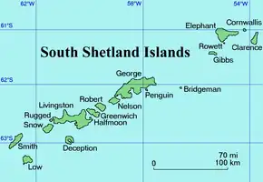

Kapka Lake (Bulgarian: езеро Капката, romanized: ezero Kapkata, IPA: ['ɛzɛro 'kapkɐtɐ]) is the 125 m long in southwest–northeast direction and 76 m wide lake on the south coast of Elephant Island in the South Shetland Islands. It has a surface area of 0.32 ha and is separated from the waters of Mendoza Cove by a 20 to 50 m wide strip of land. The area was visited by early 19th century sealers.[1]
The feature is so named because of its shape supposedly resembling a drop ('kapka' in Bulgarian).
Location
Kapka Lake is centred at 61°09′19.8″S 54°51′10″W / 61.155500°S 54.85278°W,[2] which is 8.25 km west of Walker Point. British mapping of the area in 1822,1972 and 2009.
Maps
- Chart of South Shetland including Coronation Island, &c. from the exploration of the sloop Dove in the years 1821 and 1822 by George Powell Commander of the same. Scale ca. 1:200000. London: Laurie, 1822
- Elephant Island: From a survey by the Joint Services Expedition, December 1970. Scale 1:132000 topographic map. Royal Geographical Society (UK), 1972
- British Antarctic Territory. Scale 1:200000 topographic map. DOS 610 Series, Sheet W 61 54. Directorate of Overseas Surveys, Tolworth, UK, 1972
- South Shetland Islands: Elephant, Clarence and Gibbs Islands. Scale 1:220000 topographic map. UK Antarctic Place-names Committee, 2009
- Antarctic Digital Database (ADD). Scale 1:250000 topographic map of Antarctica. Scientific Committee on Antarctic Research (SCAR). Since 1993, regularly upgraded and updated
Notes
- ↑ A. Gurney. Below the Convergence: Voyages Toward Antarctica, 1699-1839. New York: Penguin Books, 1998. 315 pp.
- ↑ Bulgarian Antarctic Gazetteer. Antarctic Place-names Commission
References
- Bulgarian Antarctic Gazetteer. Antarctic Place-names Commission. (details in Bulgarian, basic data in English)
External links
- Kapka Lake. Adjusted Copernix satellite image
This article includes information from the Antarctic Place-names Commission of Bulgaria which is used with permission.