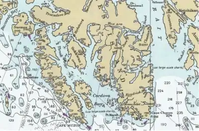

Kaigani was a major trading site for maritime fur traders and the Kaigani Haida during the maritime fur trade era of approximately 1790 to 1850. The term was used for a few nearby anchorages near several Haida settlements such as Kasaan. During this time Kaigani was one of the most popular sites for trading vessels on the Pacific Northwest coast. Hundreds of trading vessels, mostly American, visited during this time, mostly seeking sea otter skins to take to China, where they commanded a high price.[1][2]
The term "Kaigani" was used by these traders for several harbors on the eastern side of southern Dall Island near Cape Muzon, in southeast Alaska, just north of Haida Gwaii across Dixon Entrance. The word "Kaigani" also refers to the Haida who live in this area. The word continues to be used for the general locale,[3] as well as various geographical features in the area, such as Kaigani Strait, between Dall Island and Long Island, Kaigani Harbors,[4] North Kaigani Harbor,[5] and South Kaigani Harbor.[6] Historically the term often included nearby places such as Datzkoo Harbor[7] and American Bay.[8]
Maritime fur traders spelled Kaigani in many ways, including: Caiganne, Caigannee, Cargan, Clegauhny, Cygarney, Kaigahnee, Kigarnee, Kigahani, Kigahnee, Kigarny, Kigharnee, Kigharnee, Kly-garney, Ky-garney, and Kywannee.[1]
During the maritime fur trade era there were several Haida chiefs holding power in the Kaigani area or mentioned by the traders, such as Cuneah (also spelled Cunnyha, Cunnea, Cunio), Cow (Kow, Keow), Altatsee (Altadsee, Eltatsy), Kilchart, Cotseye, Lemor (Lemmato), Douglass (Duglos, Douglas) (whose name derives from a historic name exchange with the British trader William Douglas), and others.[1]
After about 1840 the Hudson's Bay Company took over the coastal fur trade and the HBC post of Fort Simpson eclipsed Kaigani as a trading site.
See also
References
- 1 2 3 Malloy, Mary (1998). "Boston Men" on the Northwest Coast: The American Maritime Fur Trade 1788-1844. Limestone Press. pp. 186–187. ISBN 978-1-895901-18-4. Retrieved 26 March 2020.
- ↑ Gibson, James R. (1999). Otter Skins, Boston Ships and China Goods: The Maritime Fur Trade of the Northwest Coast, 1785-1841. McGill-Queen's Press. pp. 206–207. ISBN 978-0-7735-2028-8. Retrieved 26 March 2020.
- ↑ U.S. Geological Survey Geographic Names Information System: Kaigani
- ↑ U.S. Geological Survey Geographic Names Information System: Kaigani Harbors
- ↑ U.S. Geological Survey Geographic Names Information System: North Kaigani Harbor
- ↑ U.S. Geological Survey Geographic Names Information System: South Kaigani Harbor
- ↑ U.S. Geological Survey Geographic Names Information System: Datzkoo Harbor
- ↑ U.S. Geological Survey Geographic Names Information System: American Bay