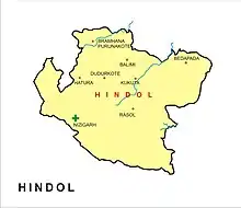
Hindol is a town and subdivision in Dhenkanal district of the Indian state of Odisha.
Geography
It is located 29 kilometres (18 mi) from NH 55 to Gudiakateni, 11 kilometres (6.8 mi) from NH 655 to Satamaili Chowk and is surrounded by reserve forest on the East, South, and West. It was a part of the Hindol princely state before independence. It is 60 kilometres (37 mi) from Dhenkanal.
Festivals
Hindol hosts five festivals every year, of which three are major. The most important of these is the Rath Yatra.
Harihat Mahotsav

Harihat Mahotsav is the oldest carnival of Hindol. The original name Harihat Mela was converted to Harihat Mahotsav in 2016. But Harihat Mela was an ancient traditional carnival of Hindol that was started many years before the Twentieth Yatra.
Hindol Laxmi Puja Committee
Hindol Town 15 Laxmi Puja Committees.
- Radhakrushna Laxmi Puja Committee, Nutanpatana
- Bus Stand Laxmi Puja Committee, Amalapada
- Maudamani Laxmi Puja Committee, Post Office
- Medical Choka Laxmi Puja Committee
- Kalapana Bazar Laxmi Puja Committee, Nizigarhapatana
- Mera Bazar Laxmi Puja Committee
- Karigar Sahi Laxmi Puja Committee
- Satya Sahi Laxmi Puja Committee, Nutanpatana-A
- Gopala Sahi Laxmi Puja Committee, Nutanpatana-B
- Banamalipur Laxmi Puja Committee
- Pitabali Laxmi Puja Committee
- Gopalapur Laxmi Puja Committee-A
- Gopalapur Laxmi Puja Committee-B
- Radhanathapura Laxmi Puja Committee
- Champati Sahi Laxmi Puja Committee
Governance
Hindol is an Odisha Legislative Assembly (Vidhan Sabha) constituency within the Dhenkanal parliamentary (Lok Sabha) constituency.[1][2]
History
Hindol was founded from Dudurkote (established before 800 AD) in 1554 by two brothers named Lakshman Mahratta and Bharat Mahratta. They belonged to the family of the Khimedi Raja of Ganjam, which also ruled over areas in the Madras region. After the East India Company occupied Odisha in September–October 1803, treaties were signed with estates of the region, including Hindol.
Rulers
| Tenure | Name |
|---|---|
| 1691–1701 | Achyuta Singh Narendra |
| 1701–1733 | Bhagabat Singh Narendra |
| 1733–1770 | Damodar Singh Narendra |
| 1770–1781 | Radhakant Singh Mardraj Jagadeb |
| 1781–1786 | Ram Chandra Singh Mardraj Jagadeb |
| 1786–1829 | Kishan Chandra Mardraj Jagadeb |
| 1829–1841 | Harihar Singh Mardraj Jagadeb |
| 1841–1874 | Ishwar Singh Mardraj Jagadeb |
| 1874–1877 | Phokar Singh Mardraj Jagadeb |
| 18 Jul 1877 – 10 Feb 1906 | Janardan Mardraj Jagadeb (b. 1853 - d. ....) |
| 10 Feb 1906 – 15 Aug 1947 | Naba Kishor Chandra Mardraj Jagadeb (b. 1891 - d. 19...) |
Sarbarakar & Royal Responsibilities
| Tenure | Name & Details |
|---|---|
| 800–1800 | Father and Forehead grandfather of Satyabadi Pratap Singh Garnaik |
| 1800–1840 | Satyabadi Pratap Singh Garnaik |
| 1840–1875 | Madhu Sardar Singh Garnaik son of Satyabadi Pratap Singh Garnaik |
| 1875–1890 | Ghasia Sardar Singh Garnaik son of Satyabadi Pratap Singh Garnaik |
| 1890 - 1906 | Champettra Sardar Singh Garnaik son of Madhu Sardar Singh Garnaik |
| 1906–1938 | Sana Adhyaksh Senapati Nakula Samant Sinhar son of Ghasia Sardar Singh Garnaik |
| 1920–1961 | Sarbarakar Fakira Charan Garnaik son of Ghasia Sardar Singh
Sadananda Garnaik son of Nakula Samant Sinhar Baikuntha Garnaik son of Sarbarakar Fakira Charan Garnai Kedar Kishor Garnaik son of Sarbarakar Fakira Charan Garnaik |
Hindol was the home to the Hindol princely state with the Odisha States Agency during the British Raj. After the East India Company occupied Odisha from September to October in 1803, treaties were signed with estates of the region, including Hindol. After Independence, the state merged into the Republic of India in 1947.[3] Thereafter in 1948, when all the princely states including Dhenkanal, Talcher, Athmallik, Pal Lahara and Hindol formally merged with the province of Odisha, the present-day Dhenkanal district was created.[4]
References
- ↑ Assembly Constituencies and their EXtent
- ↑ Seats of Odisha
- ↑ Dr. Bhagyalipi Malla (August 2007). "Amalgamation of Princely States" (PDF). Orissa Review. p. 94,98. Retrieved 18 July 2013.
- ↑ Subrata K. Mitra (31 January 2002). Power, Protest and Participation: Local Elites and Development in India. Taylor & Francis. pp. 63–. ISBN 978-0-203-22168-6. Retrieved 18 July 2013.