HaYogev
הַיּוֹגֵב | |
|---|---|
 | |
| Etymology: The Farmer | |
 HaYogev | |
| Coordinates: 32°36′42″N 35°12′17″E / 32.61167°N 35.20472°E | |
| Country | Israel |
| Council | Jezreel Valley |
| Affiliation | Moshavim Movement |
| Founded | 1949 |
| Founded by | Moshavim Movement members |
| Population (2021)[1] | 790 |
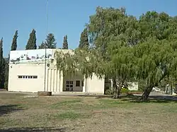
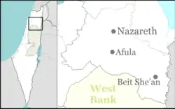
HaYogev (Hebrew: הַיּוֹגֵב, lit. The Farmer) is a moshav in northern Israel. Located around seven kilometres west of Afula, it falls under the jurisdiction of Jezreel Valley Regional Council. In 2021 it had a population of 790.[1]
Etymology
The name means "The Farmer". It consists of the Hebrew definite article Ha- ה, followed by the Hebrew word Yogev יּוֹגֵב, which means "husbandman, farmer".[2]
History
Antiquity
In September–October 2012, a trial excavation was conducted at Einot Nisanit,[3] near HaYogev Junction. In a regional survey carried out in the area, Raban reported the presence of tombs in and around the site that date to the Middle Bronze, Iron, Persian, Hellenistic, Roman, Byzantine and Ottoman periods.[4] In this site a well from the Neolithic period was discovered.[5] One find during the dig was the bones of a woman around 19 years old, and a man between 30 and 40 years old, who were described as being among the "first farmers in the Jezreel Valley." In 2018, a gardener discovered a 700-year-old bronze ring while weeding a planting bed. Galilee. The intact artifact bears an image of Saint Nicholas, who is revered in Eastern Christianity as the patron saint of travelers.[6]
Modern era
The moshav was founded in 1949 by a youth group from Austria, Germany, Romania and Israel who were members of the Beit Eshel lookout, which was destroyed during the 1948 Arab–Israeli War.[7] Part of the land had previously belonged to the depopulated Palestinian-Turkmen village of Khirbat Lid.[8][9]
The access road was paved in 1951, but only part of it, which made it difficult for the inhabitants of the moshav for years until the road was completed at the end of 1956. Each farm was allocated between 65 and 70 dunams, half of it in the orchard and half in the communal groves. However, development of the moshav was stopped in the early period due to water shortages. This problem was resolved in 1955 when the moshav was connected to the wells of Mekorot in the Megiddo region. Another problem was the theft of cows and sheep by infiltrators. At the end of 1958 the moshav was connected to the electricity grid and in 1960 a post office branch was opened in the village.[10]
The economy of the moshav is based on agriculture, including field crops, an olive press, dairy farms, poultry farms, chicken nuggets, greenhouses, as well as small businesses in various fields such as flower shops, organic crops, farm-to-table cooking workshops, horse stables which export to the Arab World and green construction. It is a home to the first free range organic-certified egg farm in Israel.[11]
References
- 1 2 "Regional Statistics". Israel Central Bureau of Statistics. Retrieved 22 February 2023.
- ↑ Klein, Ernst (1987). A comprehensive etymological dictionary of the Hebrew language. Macmillan. p. 256. ISBN 965-220-093-X.
- ↑ Tepper Y. (2014) "‘Enot Nisanit (Ha-Yogev Junction)", HA-ESI, 126
- ↑ Raban A. (2000). "Map of Mishmar Ha-‘Emeq (32)" Archaeological Survey of Israel
- ↑ Ancient Well Reveals Secrets of First Jezreel Valley Farmers Haaretz, 9 November 2012
- ↑ Bronze St. Nicholas Ring Unearthed in Israel Archaeology, 26 February 2018
- ↑ HaYogev Romgalil (in Hebrew)
- ↑ Khalidi, W. (1992). All That Remains:The Palestinian Villages Occupied and Depopulated by Israel in 1948. Washington D.C.: Institute for Palestine Studies. p. 174. ISBN 0-88728-224-5.
- ↑ Morris, B. (2004). The Birth of the Palestinian Refugee Problem Revisited. Cambridge: Cambridge University Press. p. xxii # 148. ISBN 0-521-00967-7.
- ↑ סוכנות דואר במושב היוגב Maariv, 18 May 1960
- ↑ גדי רודיק מתייחס בכבוד לתרנגולות Makor Rishon, 16 November 2010