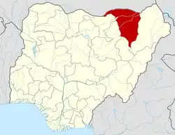
Gulani
NJ Njibulwa | |
|---|---|
| Nickname: jaguwa | |
 Gulani Location in Nigeria | |
| Coordinates: 11°00′N 11°43′E / 11.000°N 11.717°E | |
| Country | |
| State | Yobe State |
| Government | |
| • Local Government Chairman | Ahmed Musa (APC) |
| Area | |
| • Total | 2,090 km2 (810 sq mi) |
| Population (2006 census) | |
| • Total | 103,510 |
| Time zone | UTC+1 (WAT) |
| 3-digit postal code prefix | 621 |
| ISO 3166 code | NG.YO.GL |
Gulani is a Local Government Area in Yobe State, Nigeria. Its headquarters are in the town of Bara.
It has an area of 2,090 km2 and a population of 103,510 at the 2006 census.
The postal code of the area is 621.[1]
Climate
A tropical monsoon climate prevails at Gulani. All year long, there are high temperatures and a lot of rain. Gulani experiences an average yearly temperature of 65 degrees and receives about 197 inches of precipitation. With an annual average humidity of 55% and a UV-index of 7, there are 205 dry days.[2][3][4]
See also
References
- ↑ "Post Offices- with map of LGA". NIPOST. Archived from the original on 2009-10-07. Retrieved 2009-10-20.
- ↑ "Gulani weather and climate ☀️ Best time to visit 🌡️ Temperature". www.besttravelmonths.com. Retrieved 2023-09-29.
- ↑ "Weather Forecast Gulani - Nigeria (Yobe) : free 15 day weather forecasts". La Chaîne Météo (in French). Retrieved 2023-09-29.
- ↑ Vizzuality. "Gulani, Yobe, Nigeria Deforestation Rates & Statistics | GFW". www.globalforestwatch.org. Retrieved 2023-09-29.
This article is issued from Wikipedia. The text is licensed under Creative Commons - Attribution - Sharealike. Additional terms may apply for the media files.
