Goose (Otter Creek) Water Aerodrome | |||||||||||
|---|---|---|---|---|---|---|---|---|---|---|---|
 | |||||||||||
| Summary | |||||||||||
| Airport type | Public | ||||||||||
| Operator | Goose Bay Airport Corporation | ||||||||||
| Serves | Goose Bay | ||||||||||
| Location | Happy Valley-Goose Bay, Newfoundland and Labrador | ||||||||||
| Time zone | AST (UTC−04:00) | ||||||||||
| • Summer (DST) | ADT (UTC−03:00) | ||||||||||
| Elevation AMSL | 0 ft / 0 m | ||||||||||
| Coordinates | 53°21′N 060°25′W / 53.350°N 60.417°W | ||||||||||
| Map | |||||||||||
 CCB5 Location in Newfoundland and Labrador | |||||||||||
| Runways | |||||||||||
| |||||||||||
Source: Water Aerodrome Supplement[1] | |||||||||||
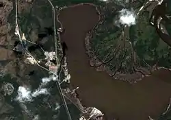
Goose (Otter Creek) Water Aerodrome (TC LID: CCB5) is located in Terrington Basin at Lake Melville, near Happy Valley-Goose Bay, Newfoundland and Labrador, Canada. It is open from June to November.
Airlines
There are two airlines that use Otter Creek, but offer only chartered hunting or fishing trips, as well as resource companies to access their mines.[2]
The airport is only in use during the summer to late fall.
Facilities
There are four piers for aircraft to park along the shore.
Fuel and airport storage (tie-down) are available at the aerodrome.[3]
There is no terminal facility, and all other services (food, transportation, medical aid, car rental) are located nearby the airport.[3]
There is no control tower, and contact is made with area control centre in Gander Airport.[3]
Transportation
The aerodrome is accessed by road via North West River Road (Route 520).
See also
- Goose Bay Airport - located 7 kilometres (4.3 mi) from Otter Creek
References
- ↑ Nav Canada's Water Aerodrome Supplement. Effective 0901Z 26 March 2020 to 0901Z 22 April 2021.
- ↑ "- OTTER CREEK - Goose Bay Airport - Freedom to Fly". Archived from the original on 2015-01-15. Retrieved 2015-01-15.
- 1 2 3 "CCB5 - Goose (Otter Creek) Seaplane Base | SkyVector".
External links