Günəşli | |
|---|---|
Municipality | |
 Günəşli | |
| Coordinates: 38°47′28″N 48°28′17″E / 38.79111°N 48.47139°E | |
| Country | |
| Rayon | Lerik |
| Population | |
| • Total | 1,022 |
| Time zone | UTC+4 (AZT) |
| • Summer (DST) | UTC+5 (AZT) |
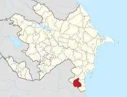
Günəşli (Talysh: Ozobijon), (until 2008,[1] Azərbaycan, Azerbagdzhan, and Azerbaydzhan) is a village and municipality in the Lerik Rayon of Azerbaijan. It has a population of 1,022. The municipality consists of the villages of Günəşli and Babagil.[2]
The village's prior name, "Azərbaycan", means "Azerbaijan" in the Azerbaijani language.
Waterfall
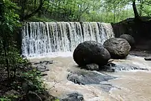
The Guneshli waterfall is a waterfall in Günəşli located at the depth of the dense forest. On May 8, 2007, by the decision of the National Assembly of the Republic of Azerbaijan the village included in the administrative territory of Noda village of Lerik region was named Guneshli.[3] Guneshli waterfall is located at a height of 1000m above sea level. The height of Guneshli waterfall is 7 meters and its width is 5 meters[4] The Gunashli waterfall swiftly flows and is divided into tributaries called Varazu and Vizazamin separately. These two tributaries together are called Lerikrivers.[5]
 The Guneshli waterfall
See also
References
- ↑ "'Bələdiyyələrin əraziləri və torpaqları haqqında' Azərbaycan Respublikasının Qanununa əlavə edilmiş 'Azərbaycan Respublikasında bələdiyyələrin siyahısı'nda dəyişikliklər edilməsi barədə" [On making changes in the 'List of municipalities in the Republic of Azerbaijan' added to the Law of the Republic of Azerbaijan 'On Territories and Lands of Municipalities']. Resolution No. 587-IIIQD of 1 April 2008 (in Azerbaijani). Milli Mejlis. Retrieved 2022-07-08.
- ↑ "Belediyye Informasiya Sistemi" (in Azerbaijani). Archived from the original on September 24, 2008.
- ↑ Administrative-division of the Republic of Azerbaijan. Data collection. Baku - 2013.
- ↑ Lerik waterfalls. Baku. Mekteb press journal. 2017.
- ↑ Г.Т.Арсеев "Водопады", Москва, 1987
