Fulton, Illinois
| |
|---|---|
 | |
 Flag | |
 Location of Fulton in Whiteside County, Illinois. | |
.svg.png.webp) Location of Illinois in the United States | |
| Coordinates: 41°52′1″N 90°9′32″W / 41.86694°N 90.15889°W | |
| Country | United States |
| State | Illinois |
| County | Whiteside |
| Area | |
| • Total | 2.80 sq mi (7.25 km2) |
| • Land | 2.34 sq mi (6.05 km2) |
| • Water | 0.46 sq mi (1.19 km2) |
| Population (2020) | |
| • Total | 3,647 |
| • Density | 1,559.88/sq mi (602.37/km2) |
| Time zone | UTC-6 (CST) |
| • Summer (DST) | UTC-5 (CDT) |
| ZIP Code(s) | 61252 |
| Area code | 815 |
| FIPS code | 17-28144 |
| Wikimedia Commons | Fulton, Illinois |
| Website | www |
Fulton is a city in Whiteside County, Illinois, United States. The population was 3,481 at the 2010 census, down from 3,881 in 2000. Fulton is located across the Mississippi River from Clinton, Iowa.
History
A post office called Fulton has been in operation since 1838.[2] The city was named for Robert Fulton, inventor of the steamboat.[3]
Geography
Fulton is located at 41°52′1″N 90°9′32″W / 41.86694°N 90.15889°W (41.866873, -90.158834),[4] on the east bank of the Mississippi River near Lock and Dam #13. The most northeastern portion of the county is in the Driftless Area of Illinois, where the Apple River meets the Upper Mississippi River.
According to the 2010 census, Fulton has a total area of 2.334 square miles (6.05 km2), of which 2.27 square miles (5.88 km2) (or 97.26%) is land and 0.064 square miles (0.17 km2) (or 2.74%) is water.[5]
Fulton is a city most known for its pride in its Dutch heritage. This is shown through the addition of a traditional Dutch windmill, De Immigrant, located near the city's dike, which borders the Mississippi. Other local attractions include: the Martin House Museum, Heritage Canyon, the Dutch Days festival held annually on the first weekend of May, and its view of the Mississippi River.
Climate
| Climate data for Fulton, Illinois (1991–2020 normals, extremes 1938–present) | |||||||||||||
|---|---|---|---|---|---|---|---|---|---|---|---|---|---|
| Month | Jan | Feb | Mar | Apr | May | Jun | Jul | Aug | Sep | Oct | Nov | Dec | Year |
| Record high °F (°C) | 62 (17) |
72 (22) |
83 (28) |
91 (33) |
96 (36) |
98 (37) |
102 (39) |
102 (39) |
96 (36) |
90 (32) |
82 (28) |
68 (20) |
102 (39) |
| Mean daily maximum °F (°C) | 29.3 (−1.5) |
33.8 (1.0) |
45.7 (7.6) |
59.4 (15.2) |
71.1 (21.7) |
80.7 (27.1) |
84.0 (28.9) |
82.1 (27.8) |
75.9 (24.4) |
63.0 (17.2) |
47.6 (8.7) |
34.8 (1.6) |
58.9 (14.9) |
| Daily mean °F (°C) | 21.4 (−5.9) |
25.4 (−3.7) |
36.9 (2.7) |
49.6 (9.8) |
61.2 (16.2) |
71.2 (21.8) |
74.6 (23.7) |
72.7 (22.6) |
65.5 (18.6) |
53.2 (11.8) |
39.5 (4.2) |
27.7 (−2.4) |
49.9 (9.9) |
| Mean daily minimum °F (°C) | 13.6 (−10.2) |
17.1 (−8.3) |
28.2 (−2.1) |
39.8 (4.3) |
51.4 (10.8) |
61.7 (16.5) |
65.2 (18.4) |
63.2 (17.3) |
55.2 (12.9) |
43.4 (6.3) |
31.4 (−0.3) |
20.5 (−6.4) |
40.9 (4.9) |
| Record low °F (°C) | −33 (−36) |
−27 (−33) |
−14 (−26) |
13 (−11) |
30 (−1) |
40 (4) |
46 (8) |
40 (4) |
26 (−3) |
13 (−11) |
−5 (−21) |
−22 (−30) |
−33 (−36) |
| Average precipitation inches (mm) | 1.40 (36) |
1.56 (40) |
2.41 (61) |
3.39 (86) |
4.03 (102) |
4.52 (115) |
3.40 (86) |
3.43 (87) |
3.66 (93) |
2.58 (66) |
2.20 (56) |
1.69 (43) |
34.27 (870) |
| Average precipitation days (≥ 0.01 in) | 6.5 | 6.3 | 8.1 | 9.9 | 10.8 | 10.5 | 7.8 | 8.2 | 7.5 | 8.0 | 6.8 | 7.4 | 97.8 |
| Source: NOAA[6][7] | |||||||||||||
Demographics
| Census | Pop. | Note | %± |
|---|---|---|---|
| 1860 | 1,512 | — | |
| 1870 | 1,875 | 24.0% | |
| 1880 | 1,733 | −7.6% | |
| 1890 | 2,099 | 21.1% | |
| 1900 | 2,685 | 27.9% | |
| 1910 | 2,174 | −19.0% | |
| 1920 | 2,445 | 12.5% | |
| 1930 | 2,656 | 8.6% | |
| 1940 | 2,585 | −2.7% | |
| 1950 | 2,706 | 4.7% | |
| 1960 | 3,387 | 25.2% | |
| 1970 | 3,630 | 7.2% | |
| 1980 | 3,936 | 8.4% | |
| 1990 | 3,698 | −6.0% | |
| 2000 | 3,881 | 4.9% | |
| 2010 | 3,481 | −10.3% | |
| 2020 | 3,647 | 4.8% | |
| U.S. Decennial Census[8] | |||
As of the census[9] of 2000, there were 3,881 people, 1,582 households, and 1,071 families residing in the city. The population density was 1,708.0 inhabitants per square mile (659.5/km2). There were 1,672 housing units at an average density of 735.8 per square mile (284.1/km2). The racial makeup of the city was 97.91% White, 0.59% African American, 0.18% Native American, 0.52% Asian, 0.33% from other races, and 0.46% from two or more races. Hispanic or Latino of any race were 1.26% of the population.
There were 1,582 households, out of which 30.6% had children under the age of 18 living with them, 56.3% were married couples living together, 8.3% had a female householder with no husband present, and 32.3% were non-families. 28.8% of all households were made up of individuals, and 12.6% had someone living alone who was 65 years of age or older. The average household size was 2.37 and the average family size was 2.89.
In the city, the population was spread out, with 23.7% under the age of 18, 7.0% from 18 to 24, 26.7% from 25 to 44, 22.5% from 45 to 64, and 20.1% who were 65 years of age or older. The median age was 40 years. For every 100 females, there were 97.7 males. For every 100 females age 18 and over, there were 94.9 males.
The median income for a household in the city was $37,068, and the median income for a family was $45,134. Males had a median income of $32,359 versus $20,653 for females. The per capita income for the city was $19,845. About 3.5% of families and 5.8% of the population were below the poverty line, including 7.8% of those under age 18 and 3.2% of those age 65 or over.
Notable people
- John R. Huizenga, professor of chemistry and physics who contributed to the Manhattan Project and the discovery of the elements Einsteinium and Fermium
- Jack Reagan, father of President Ronald Reagan
- Nelle Wilson Reagan, mother of Ronald Reagan
- Paul Rhymer, creator and writer of the radio series Vic and Sade (Born in Fulton, raised in Bloomington, Illinois)
Gallery
 Fulton (right of river) and its neighbor, Clinton, Iowa (left of river) as seen from an airplane
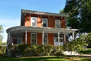
 Martin House at 707 10th Avenue
 Aerial view of Lock and Dam No. 13, located on the Mississippi River, Clinton, Iowa.
.jpg.webp) The Clinton Railroad Bridge connects Fulton and Clinton, Iowa.
The Clinton Railroad Bridge connects Fulton and Clinton, Iowa.
References
- ↑ "2020 U.S. Gazetteer Files". United States Census Bureau. Retrieved March 15, 2022.
- ↑ "Whiteside County". Jim Forte Postal History. Retrieved March 18, 2015.
- ↑ Chicago and North Western Railway Company (1908). A History of the Origin of the Place Names Connected with the Chicago & North Western and Chicago, St. Paul, Minneapolis & Omaha Railways. p. 74.
- ↑ "US Gazetteer files: 2010, 2000, and 1990". United States Census Bureau. February 12, 2011. Retrieved April 23, 2011.
- ↑ "G001 - Geographic Identifiers - 2010 Census Summary File 1". United States Census Bureau. Archived from the original on February 13, 2020. Retrieved December 27, 2015.
- ↑ "NowData – NOAA Online Weather Data". National Oceanic and Atmospheric Administration. Retrieved July 11, 2021.
- ↑ "Station: Fulton L&D #13, IL". U.S. Climate Normals 2020: U.S. Monthly Climate Normals (1991-2020). National Oceanic and Atmospheric Administration. Retrieved July 11, 2021.
- ↑ "Census of Population and Housing". Census.gov. Retrieved June 4, 2015.
- ↑ "U.S. Census website". United States Census Bureau. Retrieved January 31, 2008.
External links
- City Web site
- Fulton's Dutch Windmill "De Immigrant" history and photos.