| Forest Creek Queensland | |||||||||||||||
|---|---|---|---|---|---|---|---|---|---|---|---|---|---|---|---|
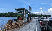
.jpg.webp) Approaching the Daintree River Ferry | |||||||||||||||
 Forest Creek | |||||||||||||||
| Coordinates | 16°14′28″S 145°22′00″E / 16.2411°S 145.3666°E | ||||||||||||||
| Population | 136 (SAL 2021)[1] | ||||||||||||||
| Postcode(s) | 4873 | ||||||||||||||
| Elevation | 0–170 m (0–558 ft) | ||||||||||||||
| Area | 22.9 km2 (8.8 sq mi) | ||||||||||||||
| Time zone | AEST (UTC+10:00) | ||||||||||||||
| Location | |||||||||||||||
| LGA(s) | Shire of Douglas | ||||||||||||||
| State electorate(s) | Cook | ||||||||||||||
| Federal division(s) | Leichhardt | ||||||||||||||
| |||||||||||||||
Forest Creek is a locality in the Shire of Douglas, Queensland, Australia.[2] In the 2021 census, Forest Creek had a population of 136 people.[3]
Geography

The Daintree River forms the southern boundary of the locality.[4] The watercourse Forest Creek flows through the locality, becoming a tributary of the Daintree River (16°15′29″S 145°23′52″E / 16.2581°S 145.3977°E).[5]
The Daintree River Ferry carries vehicles from Cape Tribulation Road in Lower Daintree across the Daintree River to Cape Tribulation Road in Forest Creek (16°15′31″S 145°23′56″E / 16.25856°S 145.39885°E).[6]
The locality contains two section of the Daintree National Park in the south-east of the locality and in the east.[7]
Virgil Island 35.2999-hectare (87.228-acre) island in the Daintree River in the south of the locality (16°15′06″S 145°21′54″E / 16.2517°S 145.3649°E).[8] It is separated from the mainland by the narrow Brandy and Water Creek (16°15′00″S 145°22′00″E / 16.25°S 145.3666°E). [9][10]
Apart from the protected areas, the eastern part of the locality are predominantly used for rural residential purposes, while the western part of the locality are predominantly used for grazing on native vegetation.[7]
History
The locality was named on 17 March 1984; it takes its name from the creek.[2]
In the 2016 census, Forest Creek had a population of 103 people.[11]
In the 2021 census, Forest Creek had a population of 136 people.[3]
Education
There are no schools in Forest Creek. The nearest government primary schools are Alexandra Bay State School in Diwan to the north-east and Daintree State School in neighbouring Daintree to the south-west (the latter requiring a ferry crossing). The nearest government secondary school is Mossman State High School in Mossman to the south (requiring a ferry crossing).[7]
References
- ↑ Australian Bureau of Statistics (28 June 2022). "Forest Creek (suburb and locality)". Australian Census 2021 QuickStats. Retrieved 28 June 2022.
- 1 2 "Forest Creek – locality in Shire of Douglas (entry 48638)". Queensland Place Names. Queensland Government. Retrieved 24 May 2019.
- 1 2 Australian Bureau of Statistics (28 June 2022). "Forest Creek (SAL)". 2021 Census QuickStats. Retrieved 28 February 2023.
- ↑ Google (20 August 2021). "Forest Creek, Queensland" (Map). Google Maps. Google. Retrieved 20 August 2021.
- ↑ "Forest Creek – watercourse in Shire of Douglas (entry 12873)". Queensland Place Names. Queensland Government. Retrieved 7 March 2023.
- ↑ "Daintree Ferry Info | Timetable & Pricing | The Daintree Ferry". Daintree Ferry. Archived from the original on 14 May 2023. Retrieved 29 May 2023.
- 1 2 3 "Queensland Globe". State of Queensland. Retrieved 29 May 2023.
- ↑ "Waterbody islands - Queensland". Queensland Open Data. Queensland Government. 12 November 2020. Archived from the original on 25 November 2020. Retrieved 25 November 2020.
- ↑ "Brandy And Water Creek – watercourse in Shire of Douglas (entry 4352)". Queensland Place Names. Queensland Government. Retrieved 7 March 2023.
- ↑ "Virgil Island – island (entry 36078)". Queensland Place Names. Queensland Government. Retrieved 25 November 2020.
- ↑ Australian Bureau of Statistics (27 June 2017). "Forest Creek (SSC)". 2016 Census QuickStats. Retrieved 20 October 2018.