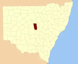
Flinders
New South Wales
Location in New South Wales
Lands administrative divisions around Flinders:
Robinson Canbelego Oxley
Mouramba Flinders Kennedy
Blaxland Cunningham Kennedy

Flinders County is one of the 141 Cadastral divisions of New South Wales. It is located to the south west of the Bogan River.

Flinders County was named in honour of the navigator, hydrographer, and scientist Matthew Flinders (1774-1814).[1]

Parishes within this county

A full list of parishes found within this county; their current LGA and mapping coordinates to the approximate centre of each location is as follows:

ParishLGACoordinates
BabegoBogan Shire31°57′54″S 146°32′04″E / 31.96500°S 146.53444°E / -31.96500; 146.53444 (Babego)
BabindaBogan Shire31°57′54″S 146°30′04″E / 31.96500°S 146.50111°E / -31.96500; 146.50111 (Babinda)
BalgayBogan Shire32°07′54″S 147°00′04″E / 32.13167°S 147.00111°E / -32.13167; 147.00111 (Balgay)
BarrowBogan Shire31°51′54″S 146°30′04″E / 31.86500°S 146.50111°E / -31.86500; 146.50111 (Barrow)
BebriBogan Shire31°49′54″S 146°38′04″E / 31.83167°S 146.63444°E / -31.83167; 146.63444 (Bebri)
BelahLachlan Shire32°08′54″S 147°10′04″E / 32.14833°S 147.16778°E / -32.14833; 147.16778 (Belah)
BirriganBogan Shire31°37′54″S 146°50′04″E / 31.63167°S 146.83444°E / -31.63167; 146.83444 (Birrigan)
BoreeBogan Shire31°33′54″S 146°42′04″E / 31.56500°S 146.70111°E / -31.56500; 146.70111 (Boree)
BudgeryBogan Shire31°33′54″S 146°34′04″E / 31.56500°S 146.56778°E / -31.56500; 146.56778 (Budgery)
BudthaBogan Shire32°02′54″S 147°09′04″E / 32.04833°S 147.15111°E / -32.04833; 147.15111 (Budtha)
BulbodnyLachlan Shire32°14′54″S 147°10′04″E / 32.24833°S 147.16778°E / -32.24833; 147.16778 (Bulbodny)
BulgaBogan Shire31°43′39″S 146°23′59″E / 31.72750°S 146.39972°E / -31.72750; 146.39972 (Bulga)
BumbaldryLachlan Shire32°23′54″S 147°07′04″E / 32.39833°S 147.11778°E / -32.39833; 147.11778 (Bumbaldry)
BurraLachlan Shire32°23′54″S 147°00′04″E / 32.39833°S 147.00111°E / -32.39833; 147.00111 (Burra)
CameronBogan Shire32°19′37″S 146°44′07″E / 32.32694°S 146.73528°E / -32.32694; 146.73528 (Cameron)
CondonBogan Shire31°45′54″S 146°34′04″E / 31.76500°S 146.56778°E / -31.76500; 146.56778 (Condon)
CoolibahBogan Shire31°55′54″S 146°56′04″E / 31.93167°S 146.93444°E / -31.93167; 146.93444 (Coolibah)
CrowieBogan Shire31°57′54″S 146°36′04″E / 31.96500°S 146.60111°E / -31.96500; 146.60111 (Crowie)
CumbineBogan Shire32°06′28″S 146°30′25″E / 32.10778°S 146.50694°E / -32.10778; 146.50694 (Cumbine)
CurrajongBogan Shire32°04′21″S 146°52′02″E / 32.07250°S 146.86722°E / -32.07250; 146.86722 (Currajong)
DelbyBogan Shire32°15′57″S 146°43′29″E / 32.26583°S 146.72472°E / -32.26583; 146.72472 (Delby)
EgeriaBogan Shire31°43′54″S 146°30′04″E / 31.73167°S 146.50111°E / -31.73167; 146.50111 (Egeria)
FirbankBogan Shire31°53′54″S 146°32′04″E / 31.89833°S 146.53444°E / -31.89833; 146.53444 (Firbank)
FosterBogan Shire31°33′54″S 146°46′04″E / 31.56500°S 146.76778°E / -31.56500; 146.76778 (Foster)
GewerooBogan Shire31°38′34″S 146°23′38″E / 31.64278°S 146.39389°E / -31.64278; 146.39389 (Geweroo)
GilgaiBogan Shire31°37′54″S 147°01′04″E / 31.63167°S 147.01778°E / -31.63167; 147.01778 (Gilgai)
GilgaiBogan Shire31°35′54″S 146°58′04″E / 31.59833°S 146.96778°E / -31.59833; 146.96778 (Gilgai)
GrahwayBogan Shire32°14′21″S 146°33′05″E / 32.23917°S 146.55139°E / -32.23917; 146.55139 (Grahway)
GrayriggBogan Shire31°39′54″S 146°40′04″E / 31.66500°S 146.66778°E / -31.66500; 146.66778 (Grayrigg)
HermitageBogan Shire31°55′54″S 146°48′04″E / 31.93167°S 146.80111°E / -31.93167; 146.80111 (Hermitage)
Hermitage PlainsBogan Shire31°53′54″S 146°42′04″E / 31.89833°S 146.70111°E / -31.89833; 146.70111 (Hermitage Plains)
HoneybugleBogan Shire31°49′54″S 146°56′04″E / 31.83167°S 146.93444°E / -31.83167; 146.93444 (Honeybugle)
HoneybugleBogan Shire31°51′54″S 147°01′04″E / 31.86500°S 147.01778°E / -31.86500; 147.01778 (Honeybugle)
HowgillBogan Shire31°47′54″S 146°30′04″E / 31.79833°S 146.50111°E / -31.79833; 146.50111 (Howgill)
KeenanBogan Shire31°41′54″S 146°56′04″E / 31.69833°S 146.93444°E / -31.69833; 146.93444 (Keenan)
KeenanBogan Shire31°43′54″S 147°02′04″E / 31.73167°S 147.03444°E / -31.73167; 147.03444 (Keenan)
KinnearBogan Shire32°07′56″S 146°43′28″E / 32.13222°S 146.72444°E / -32.13222; 146.72444 (Kinnear)
LambriggBogan Shire31°39′54″S 146°34′04″E / 31.66500°S 146.56778°E / -31.66500; 146.56778 (Lambrigg)
MerrilbaBogan Shire31°55′54″S 147°04′04″E / 31.93167°S 147.06778°E / -31.93167; 147.06778 (Merrilba)
Miamley NorthLachlan Shire32°20′52″S 146°54′39″E / 32.34778°S 146.91083°E / -32.34778; 146.91083 (Miamley North)
MiandettaBogan Shire31°37′54″S 147°06′04″E / 31.63167°S 147.10111°E / -31.63167; 147.10111 (Miandetta)
MinalongLachlan Shire32°18′54″S 147°10′04″E / 32.31500°S 147.16778°E / -32.31500; 147.16778 (Minalong)
MogilleLachlan Shire32°18′38″S 146°50′52″E / 32.31056°S 146.84778°E / -32.31056; 146.84778 (Mogille)
Mogille PlainLachlan Shire32°20′54″S 147°00′04″E / 32.34833°S 147.00111°E / -32.34833; 147.00111 (Mogille Plain)
MogundaleLachlan Shire32°15′04″S 146°51′07″E / 32.25111°S 146.85194°E / -32.25111; 146.85194 (Mogundale)
MullahBogan Shire31°45′54″S 146°36′04″E / 31.76500°S 146.60111°E / -31.76500; 146.60111 (Mullah)
MurrabuddaBogan Shire31°43′54″S 147°06′04″E / 31.73167°S 147.10111°E / -31.73167; 147.10111 (Murrabudda)
Myall CowallBogan Shire32°02′54″S 147°04′04″E / 32.04833°S 147.06778°E / -32.04833; 147.06778 (Myall Cowall)
NangeryboneBogan Shire32°19′57″S 146°35′48″E / 32.33250°S 146.59667°E / -32.33250; 146.59667 (Nangerybone)
NardooBogan Shire31°41′54″S 146°48′04″E / 31.69833°S 146.80111°E / -31.69833; 146.80111 (Nardoo)
OberonLachlan Shire32°17′54″S 147°03′04″E / 32.29833°S 147.05111°E / -32.29833; 147.05111 (Oberon)
PangeeBogan Shire31°57′54″S 146°42′04″E / 31.96500°S 146.70111°E / -31.96500; 146.70111 (Pangee)
Pangee CreekBogan Shire31°49′54″S 146°46′04″E / 31.83167°S 146.76778°E / -31.83167; 146.76778 (Pangee Creek)
QuandaBogan Shire31°43′54″S 146°42′04″E / 31.73167°S 146.70111°E / -31.73167; 146.70111 (Quanda)
QuondongBogan Shire31°45′54″S 146°52′04″E / 31.76500°S 146.86778°E / -31.76500; 146.86778 (Quondong)
Red GilgaisBogan Shire31°57′54″S 146°56′04″E / 31.96500°S 146.93444°E / -31.96500; 146.93444 (Red Gilgais)
Red GilgaisBogan Shire32°01′54″S 147°00′04″E / 32.03167°S 147.00111°E / -32.03167; 147.00111 (Red Gilgais)
ReganBogan Shire31°51′54″S 146°52′04″E / 31.86500°S 146.86778°E / -31.86500; 146.86778 (Regan)
TalgongBogan Shire32°10′30″S 146°52′11″E / 32.17500°S 146.86972°E / -32.17500; 146.86972 (Talgong)
The BluffLachlan Shire32°27′42″S 146°53′02″E / 32.46167°S 146.88389°E / -32.46167; 146.88389 (The Bluff)
The OverflowBogan Shire32°12′05″S 146°38′31″E / 32.20139°S 146.64194°E / -32.20139; 146.64194 (The Overflow)
UmangBogan Shire32°07′54″S 147°04′04″E / 32.13167°S 147.06778°E / -32.13167; 147.06778 (Umang)
Walkers HillBogan Shire32°23′45″S 146°47′29″E / 32.39583°S 146.79139°E / -32.39583; 146.79139 (Walkers Hill)
WaltonBogan Shire32°10′26″S 146°34′16″E / 32.17389°S 146.57111°E / -32.17389; 146.57111 (Walton)
WalwaBogan Shire32°06′04″S 146°36′55″E / 32.10111°S 146.61528°E / -32.10111; 146.61528 (Walwa)
WharfdaleBogan Shire32°12′54″S 147°02′04″E / 32.21500°S 147.03444°E / -32.21500; 147.03444 (Wharfdale)
Wharfdale NorthBogan Shire32°11′33″S 146°57′19″E / 32.19250°S 146.95528°E / -32.19250; 146.95528 (Wharfdale North)
WhitbarrowBogan Shire31°33′54″S 146°50′04″E / 31.56500°S 146.83444°E / -31.56500; 146.83444 (Whitbarrow)
WicklowBogan Shire31°57′54″S 146°58′04″E / 31.96500°S 146.96778°E / -31.96500; 146.96778 (Wicklow)
WicklowBogan Shire31°59′54″S 147°00′04″E / 31.99833°S 147.00111°E / -31.99833; 147.00111 (Wicklow)
WidgelandBogan Shire31°49′54″S 147°02′04″E / 31.83167°S 147.03444°E / -31.83167; 147.03444 (Widgeland)
WilmathaLachlan Shire32°27′54″S 147°03′04″E / 32.46500°S 147.05111°E / -32.46500; 147.05111 (Wilmatha)
WinfellBogan Shire31°39′54″S 146°30′04″E / 31.66500°S 146.50111°E / -31.66500; 146.50111 (Winfell)
YammaBogan Shire31°37′54″S 146°44′04″E / 31.63167°S 146.73444°E / -31.63167; 146.73444 (Yamma)
YarrowBogan Shire31°55′54″S 146°36′04″E / 31.93167°S 146.60111°E / -31.93167; 146.60111 (Yarrow)
YoongeeBogan Shire31°33′54″S 146°30′04″E / 31.56500°S 146.50111°E / -31.56500; 146.50111 (Yoongee)

References

  1. "Flinders County". Geographical Names Register (GNR) of NSW. Geographical Names Board of New South Wales.
This article is issued from Wikipedia. The text is licensed under Creative Commons - Attribution - Sharealike. Additional terms may apply for the media files.