Dunagan, Texas | |
|---|---|
 Dunagan  Dunagan | |
| Coordinates: 31°20′48″N 94°36′55″W / 31.3465745°N 94.6152066°W | |
| Country | United States |
| State | Texas |
| County | Angelina |
| Elevation | 305 ft (93 m) |
| Time zone | UTC-6 (Central (CST)) |
| • Summer (DST) | UTC-5 (CDT) |
| Area code | 936 |
| GNIS feature ID | 1381806[1] |
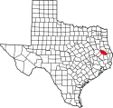
Dunagan is a ghost town in Angelina County, in the U.S. state of Texas.[1] It is located within the Lufkin, Texas micropolitan area.
History
Dunagan was named for a man named Isaac Dunagan and was first settled in the early 1840s (before Angelina County was established). The first commissioners' court in the county met at Dunagan's house in 1846. The community, as well as nearby Moses Bluff, were up for a vote on being the county seat after the county was established in 1846. Moses Bluff won the vote 26:2. To appease dissatisfied voters, another election was held, but this time, Moses Bluff had 39 votes, while Dunagan again only had two. For election purposes, Moses Bluff was designated as River Place for its location on the Angelina River, while Dunagan went by the name Center. It became a ghost town afterward, and only a railroad siding was in the area in the 1980s.[2]
The Angelina and Neches River Railroad operates a line traveling 11.6 miles (18.7 km) to an interchange with the Union Pacific Railroad in Lufkin. The ghost town is located within the Lufkin Independent School District.
Geography
Dunagan was located 7 mi (11 km) east of Lufkin and 5 mi (8.0 km) northwest of Huntington in central Angelina County.[2]
See also
References
- 1 2 3 U.S. Geological Survey Geographic Names Information System: Dunagan, Texas
- 1 2 Biesele, Megan (1994-12-01). "Dunagan, TX". tshaonline.org.
