Drtija | |
|---|---|
 | |
 Drtija Location in Slovenia | |
| Coordinates: 46°7′38.71″N 14°45′26.98″E / 46.1274194°N 14.7574944°E | |
| Country | |
| Traditional region | Upper Carniola |
| Statistical region | Central Slovenia |
| Municipality | Moravče |
| Area | |
| • Total | 3.2 km2 (1.2 sq mi) |
| Elevation | 377 m (1,237 ft) |
| Population (2002) | |
| • Total | 191 |
| [1] | |
Drtija (pronounced [dəɾˈtiːja]; German: Drittai[2]) is a settlement in the Municipality of Moravče in central Slovenia. The area is part of the traditional region of Upper Carniola. It is now included with the rest of the municipality in the Central Slovenia Statistical Region.[3] The settlement includes the hamlets of Belnek, Brinje, Gorica, Kovačija, Podbrdo, Kuga, Štance Laze, Štebalija, Štorovje, and Straža.[4] Before the First World War, the hamlets scattered along the Slivna Plateau were collectively known as Za Goro (German: Mariae Virginis).[2][5]
Name
Drtija was mentioned in written sources as Dritey in 1320, Dretey in 1322, Dritey in 1335, Drittey in 1405, and Dreytey in 1436, among other spellings.[6][7] The original name has been reconstructed as *Drětija, which may be derived from the verb *drěti 'to tear, clear (land)'. If so, the name means 'cleared land'.[7]
Belnek Castle
Belnek Castle (German: Wildeneck,[8] Wildenegg[2]) stood on a low rise in the former village of Belnek, which was annexed by Drtija in 1952.[9][10]
Church

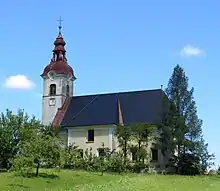
The local church is dedicated to Mary Queen of Angels. It dates to the mid-18th century and belongs to the Parish of Moravče.[11]
References
- ↑ Statistical Office of the Republic of Slovenia
- 1 2 3 Leksikon občin kraljestev in dežel zastopanih v državnem zboru, vol. 6: Kranjsko. 1906. Vienna: C. Kr. Dvorna in Državna Tiskarna, pp. 18–19.
- ↑ Moravče municipal site
- ↑ Savnik, Roman, ed. 1971. Krajevni leksikon Slovenije, vol. 2. Ljubljana: Državna založba Slovenije, p. 85.
- ↑ Laibach (map, 1:75,000). 1918. Vienna: K. u. k. Militärgeographisches Institut.
- ↑ "Drtija". Slovenska historična topografija. ZRC SAZU Zgodovinski inštitut Milka Kosa. Retrieved October 30, 2020.
- 1 2 Snoj, Marko. 2009. Etimološki slovar slovenskih zemljepisnih imen. Ljubljana: Modrijan and Založba ZRC, p. 127.
- ↑ Gradovi v Sloveniji. Belnek. (in Slovene)
- ↑ Marinković, Dragan (1991). Abecedni spisak naselja u SFRJ. Promene u sastavu i nazivima naselja za period 1948–1990. Belgrade: Savezni zavod za statistiku. pp. 4, 27.
- ↑ Razširjeni seznam sprememb naselij: od 1948 do 1964: (poimenovanja, združevanja, odcepitve, pristavki, razglastive in ukinitve). Ljubljana: Zavod SR Slovenije za statistiko. 1965. pp. 6, 28.
- ↑ Slovenian Ministry of Culture register of national heritage reference number ešd 2061
External links
 Media related to Drtija at Wikimedia Commons
- Drtija on Geopedia
