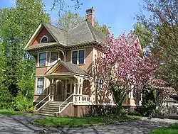
Deas Island is a peninsula in the south arm of the Fraser River between Delta, British Columbia and Richmond, British Columbia, Canada. It is home to a regional park approximately 300 acres (120 ha) in size; and has three historic buildings: Burrvilla, a stately Victorian home; Inverholme, a one-room schoolhouse; and the Delta Agricultural Hall. Between 1895 and the 1940s, the peninsula had a small Greek settlement with a population of about 80 at its peak.[1]
It is a habitat for many kinds of birds, and a popular bird-watching destination.
The peninsula is notable as the site of the southern end of the George Massey Tunnel (originally the Deas Island Tunnel), which is part of Highway 99 and connects Delta to Richmond. The tunnel goes from Deas Island to Lulu Island (Richmond) to the north. A small bridge completes the connection between Deas Island and the main part of Delta.
A portion of Deas Island is occupied by Deas Island Regional Park.

Origin of the name
The peninsula was named for John Sullivan Deas, an African-Canadian tinsmith who established a cannery on the peninsula in 1873.[2] His was the leading cannery on the Fraser River until 1878, at which point growing competition encouraged Deas to sell.[3]
References
- ↑ "Greek settlers endured tough conditions on Deas Island". Delta Optimist. Retrieved 2022-05-29.
- ↑ "...there is little doubt that Deas himself was...the actual owner of the cannery. He acquired the land through pre-emption and the improvements were in his name. The canned salmon produced by the plant was also marketed in Deas' name, if we accept the evidence of a gaily coloured salmon label — the earliest of its kind to survive from the British Columbia industry — bearing the legend 'Fresh Salmon, John S. Deas, Frazer [sic] River, British Columbia.'" Ralston, Keith. "John Sullivan Deas: A Black Entrepreneur in British Columbia Salmon Canning." Archived 2014-07-26 at the Wayback Machine BC Studies: The British Columbian Quarterly 32 (1976): 71."
- ↑ Ralston, Keith. "John Sullivan Deas: A Black Entrepreneur in British Columbia Salmon Canning." Archived 2014-07-26 at the Wayback Machine BC Studies: The British Columbian Quarterly 32 (1976): 73-76."
External links
49°07′16″N 123°03′54″W / 49.121°N 123.065°W