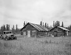
Chisana
Tsetsaan' Na' | |
|---|---|
 Chisana's post office | |
 Chisana Location within the state of Alaska | |
| Coordinates: 62°03′58″N 142°02′27″W / 62.06611°N 142.04083°W | |
| Country | United States |
| State | Alaska |
| Census Area | Copper River |
| Government | |
| • State senator | Click Bishop (R) |
| • State rep. | Mike Cronk (R) |
| Area | |
| • Total | 79.44 sq mi (205.74 km2) |
| • Land | 79.39 sq mi (205.61 km2) |
| • Water | 0.05 sq mi (0.13 km2) |
| Elevation | 3,369 ft (1,027 m) |
| Population (2020) | |
| • Total | 0 |
| • Density | 0.00/sq mi (0.00/km2) |
| Time zone | UTC-9 (Alaska (AKST)) |
| • Summer (DST) | UTC-8 (AKDT) |
| Area code | 907 |
| FIPS code | 02-13890 |
| GNIS feature ID | 1400321 |
Chisana Historic District | |
Alaska Heritage Resources Survey
| |
| Location | Extending west 0.25 miles (0.40 km) from the southern end of Chisana Airstrip |
|---|---|
| Nearest city | Northway |
| Coordinates | 62°03′56″N 142°02′49″W / 62.06551°N 142.04681°W |
| Area | 30 acres (12 ha) |
| Built | 1913 |
| NRHP reference No. | 85002999[2] |
| AHRS No. | NAB-042 |
| Significant dates | |
| Added to NRHP | November 29, 1985 |
| Designated AHRS | 1984 |
Chisana Historic Mining Landscape | |
| Location | Address restricted[3] |
|---|---|
| Nearest city | Northway |
| Area | 27,216 acres (11,014 ha) |
| Built | 1913 |
| NRHP reference No. | 98000436[2] |
| Added to NRHP | May 14, 1998 |
Chisana (also Shushanna) (Tsetsaan' Na in Ahtna) is a census-designated place (CDP) in the Copper River Census Area in the U.S. state of Alaska. As of the 2010 Census,[4] the population of the CDP was 0. The English name Chisana derives from the Ahtna Athabascan name Tsetsaan' Na, meaning literally 'copper river' (not to be confused with the river known in English as the Copper River). The Chisana River joins the Nabesna River just north of Northway Junction, Alaska, to form the Tanana River, a major tributary of the Yukon River.[5] The Chisana Airport consists of a turf and gravel runway which is largely serviced by flights from Tok, Alaska.
In 1985, the community was listed as Chisana Historic District on the National Register of Historic Places as a historic district.[6][7]
In 1998 the Chisana Historic Mining Landscape historic district, comprising the community and a wide 27,000 acres (11,000 ha) area located partly in Copper River Census Area and partly in Southeast Fairbanks Census Area, was listed on the National Register of Historic Places.[8][9]
Geography
According to the United States Census Bureau, the CDP has a total area of 86.7 square miles (225 km2), of which 86.7 square miles (225 km2) of it is land and 0.1 square miles (0.26 km2) of it is water. The total area is 0.10% water.
Climate
According to the Köppen Climate Classification system, Chisana has a subarctic climate, abbreviated "Dfc" on climate maps. The hottest temperature recorded in Chisana was 90 °F (32.2 °C) on June 19–20, 2004, while the coldest temperature recorded was −53 °F (−47.2 °C) on January 7, 2013.[10]
| Climate data for Chisana, Alaska, 2006–2020 normals, extremes 1992–present | |||||||||||||
|---|---|---|---|---|---|---|---|---|---|---|---|---|---|
| Month | Jan | Feb | Mar | Apr | May | Jun | Jul | Aug | Sep | Oct | Nov | Dec | Year |
| Record high °F (°C) | 53 (12) |
53 (12) |
63 (17) |
68 (20) |
79 (26) |
90 (32) |
87 (31) |
89 (32) |
75 (24) |
74 (23) |
45 (7) |
55 (13) |
90 (32) |
| Mean maximum °F (°C) | 33.9 (1.1) |
41.0 (5.0) |
47.3 (8.5) |
57.4 (14.1) |
70.8 (21.6) |
77.6 (25.3) |
80.1 (26.7) |
78.3 (25.7) |
67.8 (19.9) |
55.7 (13.2) |
31.9 (−0.1) |
31.5 (−0.3) |
81.8 (27.7) |
| Mean daily maximum °F (°C) | 2.2 (−16.6) |
17.7 (−7.9) |
28.1 (−2.2) |
44.4 (6.9) |
56.9 (13.8) |
64.8 (18.2) |
68.9 (20.5) |
64.5 (18.1) |
54.0 (12.2) |
35.8 (2.1) |
10.8 (−11.8) |
2.9 (−16.2) |
37.6 (3.1) |
| Daily mean °F (°C) | −8.1 (−22.3) |
1.3 (−17.1) |
8.3 (−13.2) |
27.1 (−2.7) |
41.7 (5.4) |
49.7 (9.8) |
53.4 (11.9) |
48.7 (9.3) |
39.3 (4.1) |
21.9 (−5.6) |
−0.2 (−17.9) |
−5.9 (−21.1) |
23.1 (−5.0) |
| Mean daily minimum °F (°C) | −18.2 (−27.9) |
−15.1 (−26.2) |
−11.5 (−24.2) |
9.8 (−12.3) |
26.4 (−3.1) |
34.5 (1.4) |
37.8 (3.2) |
32.9 (0.5) |
24.5 (−4.2) |
7.9 (−13.4) |
−11.2 (−24.0) |
−14.5 (−25.8) |
8.6 (−13.0) |
| Mean minimum °F (°C) | −40.4 (−40.2) |
−36.1 (−37.8) |
−32.6 (−35.9) |
−11.0 (−23.9) |
15.1 (−9.4) |
24.0 (−4.4) |
27.1 (−2.7) |
22.2 (−5.4) |
9.9 (−12.3) |
−15.3 (−26.3) |
−32.1 (−35.6) |
−33.7 (−36.5) |
−46.3 (−43.5) |
| Record low °F (°C) | −53 (−47) |
−52 (−47) |
−49 (−45) |
−39 (−39) |
2 (−17) |
19 (−7) |
24 (−4) |
16 (−9) |
−5 (−21) |
−31 (−35) |
−44 (−42) |
−49 (−45) |
−53 (−47) |
| Average precipitation inches (mm) | 0.53 (13) |
0.57 (14) |
0.37 (9.4) |
0.25 (6.4) |
1.02 (26) |
3.22 (82) |
2.55 (65) |
1.54 (39) |
1.10 (28) |
0.80 (20) |
0.70 (18) |
0.60 (15) |
13.25 (335.8) |
| Average extreme snow depth inches (cm) | 15.4 (39) |
18.3 (46) |
18.7 (47) |
17.7 (45) |
8.1 (21) |
0.0 (0.0) |
0.0 (0.0) |
0.0 (0.0) |
1.1 (2.8) |
4.9 (12) |
12.3 (31) |
15.4 (39) |
20.3 (52) |
| Average precipitation days (≥ 0.01 in) | 3.7 | 4.4 | 3.2 | 1.9 | 5.6 | 12.3 | 9.4 | 9.6 | 5.7 | 5.3 | 4.5 | 3.7 | 69.3 |
| Source 1: NOAA[11] | |||||||||||||
| Source 2: National Weather Service[10] | |||||||||||||
Demographics
| Census | Pop. | Note | %± |
|---|---|---|---|
| 1920 | 148 | — | |
| 1930 | 13 | −91.2% | |
| 1940 | 28 | 115.4% | |
| 2020 | 0 | — | |
| U.S. Decennial Census[12] | |||
Chisana first appeared on the 1920 U.S. Census as an unincorporated community. It appeared twice more in 1930 and 1940. It would not appear again until 2000, when it was made a census-designated place (CDP). However, in both 2000 and 2010, it reported no residents.
See also
References
- ↑ "2020 U.S. Gazetteer Files". United States Census Bureau. Retrieved October 29, 2021.
- 1 2 "National Register Information System". National Register of Historic Places. National Park Service. July 9, 2010.
- ↑ Federal and state laws and practices restrict general public access to information regarding the specific location of this resource. In some cases, this is to protect archeological sites from vandalism, while in other cases it is restricted at the request of the owner. See: Knoerl, John; Miller, Diane; Shrimpton, Rebecca H. (1990), Guidelines for Restricting Information about Historic and Prehistoric Resources, National Register Bulletin, National Park Service, U.S. Department of the Interior, OCLC 20706997.
- ↑ "U.S. Census website". United States Census Bureau. Retrieved January 31, 2008.
- ↑ Alaska Atlas & Gazetteer (7th ed.). Yarmouth, Maine: DeLorme. 2010. pp. 98–99, 109. ISBN 978-0-89933-289-5.
- ↑ "NRHP nomination for Chisana Historic District". National Park Service. Retrieved June 9, 2017.
- ↑ "National Register of Historical Places - ALASKA (AK), Valdez-Cordova County". Retrieved June 9, 2017.
- ↑ "NRHP nomination for Chisana Historic Mining Landscape". National Park Service. Retrieved June 9, 2017.
- ↑ "National Register of Historical Places - ALASKA (AK), Southeast Fairbanks County". Retrieved June 9, 2017.
- 1 2 "NOAA Online Weather Data – NWS Fairbanks". National Weather Service. Retrieved November 26, 2022.
- ↑ "U.S. Climate Normals Quick Access – Station: Chisana, AK". National Oceanic and Atmospheric Administration. Retrieved November 26, 2022.
- ↑ "U.S. Decennial Census". Census.gov. Retrieved June 6, 2013.


.svg.png.webp)