Chengkou
城口县 Chengkow | |
|---|---|
 | |
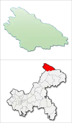
 Location of Chengkou County in Chongqing | |
| Coordinates: 31°52′30″N 108°42′00″E / 31.875°N 108.7°E | |
| Country | People's Republic of China |
| Municipality | Chongqing |
| Area | |
| • Total | 3,289.1 km2 (1,269.9 sq mi) |
| Population (2010)[1] | |
| • Total | 192,967 |
| • Density | 59/km2 (150/sq mi) |
| Time zone | UTC+8 (China Standard) |
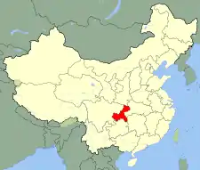
Chengkou County (Chinese: 城口县; pinyin: Chéngkǒu Xiàn) is a county in Chongqing municipality, China, and is the northernmost county-level division of Chongqing, bordering the provinces of Shaanxi and Sichuan to the north and west, respectively. To the northeast, the county borders Zhengping County, Pingli County, Langao County and Ziyang County of Ankang, Shaanxi. To the west, the county borders Wanyuan and Xuanhan County of Dazhou, Sichuan. To the south, the county borders Chongqing's Kaizhou District and Wuxi County.
The county is mountainous, covering most of the Daba Mountains in Chongqing municipality.
Local delicacies are bacon, tea, honey, and walnut oil.[2]
Administrative divisions
Chengkou County is composed of two subdistricts, ten towns, and thirteen townships.[1][3][4] It formerly had 7 towns and 17 townships.[5]
Two subdistricts (街道):
Ten towns (镇):
- Bashan (巴山镇), Pingba (坪坝镇), Miaoba (庙坝镇), Mingtong (明通镇), Xiuqi (修齐镇), Gaoguan (高观镇), Gaoyan (高燕镇, before 2012 Gaoyan Township (高燕乡)), Dong'an (东安镇, before 2014 Dong'an Township (东安乡)), Xianyi (咸宜镇, before 2014 Xianyi Township (咸宜乡)), Gaonan (高楠镇, before 2014 Gaonan Township (高楠乡))
Thirteen townships (乡):
- Longtian Township (龙田乡), Beiping Township (北屏乡), Zuolan Township (左岚乡), Yanhe Township (沿河乡), Shuanghe Township (双河乡), Liaozi Township (蓼子乡), Jiming Township (鸡鸣乡), Zhouxi Township (周溪乡), Mingzhong Township (明中乡), Zhiping Township (治平乡), Lantian Township (岚天乡), Houping Township (厚坪乡), Heyu Township (河鱼乡)
Climate
| Climate data for Chengkou (1991–2020 normals, extremes 1981–2010) | |||||||||||||
|---|---|---|---|---|---|---|---|---|---|---|---|---|---|
| Month | Jan | Feb | Mar | Apr | May | Jun | Jul | Aug | Sep | Oct | Nov | Dec | Year |
| Record high °C (°F) | 23.2 (73.8) |
27.7 (81.9) |
32.3 (90.1) |
35.3 (95.5) |
37.7 (99.9) |
40.0 (104.0) |
38.5 (101.3) |
39.5 (103.1) |
39.3 (102.7) |
33.0 (91.4) |
26.4 (79.5) |
21.0 (69.8) |
40.0 (104.0) |
| Mean daily maximum °C (°F) | 7.9 (46.2) |
10.7 (51.3) |
16.1 (61.0) |
22.2 (72.0) |
25.4 (77.7) |
28.5 (83.3) |
31.1 (88.0) |
31.1 (88.0) |
25.7 (78.3) |
20.2 (68.4) |
14.9 (58.8) |
9.5 (49.1) |
20.3 (68.5) |
| Daily mean °C (°F) | 2.9 (37.2) |
5.3 (41.5) |
9.5 (49.1) |
14.9 (58.8) |
18.4 (65.1) |
21.9 (71.4) |
24.4 (75.9) |
24.0 (75.2) |
19.6 (67.3) |
14.4 (57.9) |
9.2 (48.6) |
4.2 (39.6) |
14.1 (57.3) |
| Mean daily minimum °C (°F) | −0.1 (31.8) |
1.9 (35.4) |
5.3 (41.5) |
10.0 (50.0) |
13.8 (56.8) |
17.5 (63.5) |
20.2 (68.4) |
19.7 (67.5) |
16.1 (61.0) |
11.3 (52.3) |
5.9 (42.6) |
1.1 (34.0) |
10.2 (50.4) |
| Record low °C (°F) | −6.9 (19.6) |
−4.8 (23.4) |
−5.0 (23.0) |
−0.1 (31.8) |
5.3 (41.5) |
10.0 (50.0) |
12.4 (54.3) |
13.2 (55.8) |
8.0 (46.4) |
−1.6 (29.1) |
−3.5 (25.7) |
−12.3 (9.9) |
−12.3 (9.9) |
| Average precipitation mm (inches) | 17.6 (0.69) |
25.4 (1.00) |
58.4 (2.30) |
84.0 (3.31) |
146.9 (5.78) |
173.3 (6.82) |
220.0 (8.66) |
164.9 (6.49) |
169.6 (6.68) |
119.9 (4.72) |
47.0 (1.85) |
18.6 (0.73) |
1,245.6 (49.03) |
| Average precipitation days (≥ 0.1 mm) | 9.4 | 9.3 | 12.6 | 13.3 | 14.6 | 15.3 | 15.8 | 14.5 | 14.2 | 14.1 | 11.0 | 9.2 | 153.3 |
| Average snowy days | 8.6 | 5.0 | 1.9 | 0.2 | 0 | 0 | 0 | 0 | 0 | 0 | 1.0 | 4.3 | 21 |
| Average relative humidity (%) | 78 | 76 | 73 | 74 | 77 | 79 | 81 | 80 | 83 | 84 | 82 | 80 | 79 |
| Mean monthly sunshine hours | 67.7 | 64.7 | 103.3 | 133.0 | 141.0 | 140.0 | 172.4 | 182.8 | 115.7 | 97.8 | 87.4 | 76.5 | 1,382.3 |
| Percent possible sunshine | 21 | 21 | 28 | 34 | 33 | 33 | 40 | 45 | 32 | 28 | 28 | 25 | 31 |
| Source: China Meteorological Administration[6][7] | |||||||||||||
References
- 1 2 3 城口县历史沿革 [Chengkou County Historical Development] (in Simplified Chinese). XZQH.org. 4 January 2015. Retrieved 14 March 2019.
1996年,城口县面积3285.9平方千米,{...}2009年12月1日,重庆市政府(渝府[2009]179号)批复同意撤销葛城镇,设立葛城街道、复兴街道。{...}2010年第六次人口普查,城口县常住总人口192967人,{...}2012年12月20日,重庆市政府(渝府[2012]106号)批复同意城口县撤销高燕乡设立高燕镇。2014年8月19日,重庆市政府(渝府[2014]52号)批复同意:撤销东安乡,设立东安镇;撤销咸宜乡,设立咸宜镇;撤销高楠乡,设立高楠镇。调整后,城口县辖2个街道、10个镇、13个乡:葛城街道、复兴街道、巴山镇、坪坝镇、庙坝镇、明通镇、修齐镇、高观镇、高燕镇、东安镇、咸宜镇、高楠镇、龙田乡、北屏乡、左岚乡、沿河乡、双河乡、蓼子乡、鸡鸣乡、周溪乡、明中乡、治平乡、岚天乡、厚坪乡、河鱼乡。
- ↑ Hu, Rui (2020-09-08). "Chengkou Livestream: Broadcast Its Rich History and Tasty Food". iChongqing. Retrieved 2024-01-03.
- ↑ 行政区划 [Administrative Divisions]. 重庆市城口县人民政府公众信息网 (in Simplified Chinese). Retrieved 14 March 2019.
全县幅员面积3289.1平方公里,{...}县内辖2街道(葛城街道、复兴街道)10镇(高燕镇、巴山镇、坪坝镇、修齐镇、庙坝镇、明通镇、高观镇、高楠镇、咸宜镇、东安镇)13乡(蓼子乡、左岚乡、北屏乡、双河乡、沿河乡、厚坪乡、治坪乡、岚天乡、周溪乡、河鱼乡、明中乡、龙田乡、鸡鸣乡)。
- ↑ 2018年统计用区划代码和城乡划分代码:城口县 [2018 Statistical Area Numbers and Rural-Urban Area Numbers: Chengkou County] (in Simplified Chinese). National Bureau of Statistics of the People's Republic of China. 2018. Retrieved 14 March 2019.
统计用区划代码 名称 500229001000 葛城街道办事处 500229002000 复兴街道办事处 500229102000 巴山镇 500229103000 坪坝镇 500229104000 庙坝镇 500229105000 明通镇 500229106000 修齐镇 500229107000 高观镇 500229108000 高燕镇 500229109000 东安镇 500229110000 咸宜镇 500229111000 高楠镇 500229201000 龙田乡 500229202000 北屏乡 500229205000 左岚乡 500229208000 沿河乡 500229210000 双河乡 500229211000 蓼子乡 500229212000 鸡鸣乡 500229214000 周溪乡 500229216000 明中乡 500229217000 治平乡 500229219000 岚天乡 500229220000 厚坪乡 500229221000 河鱼乡
- ↑ "Profile of Chengkou County" (in Chinese). Archived from the original on 2008-06-10. Retrieved 2008-08-03.
- ↑ 中国气象数据网 – WeatherBk Data (in Simplified Chinese). China Meteorological Administration. Retrieved 28 April 2023.
- ↑ 中国气象数据网 (in Simplified Chinese). China Meteorological Administration. Retrieved 28 April 2023.

