| Central Moravian Carpathians | |
|---|---|
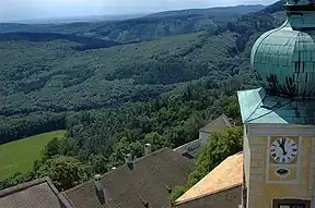
 Buchlov Castle in the Chřiby highlands | |
| Highest point | |
| Peak | Brdo |
| Elevation | 587 m (1,926 ft) |
| Coordinates | 49°10′16″N 17°18′32″E / 49.17111°N 17.30889°E |
| Naming | |
| Native name | Středomoravské Karpaty (Czech) |
| Geography | |
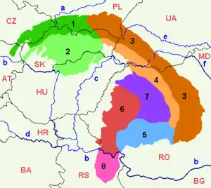
 Central Moravian Carpathians (marked in red) within the Outer Western Carpathians
| |
| Country | Czech Republic |
| Regions | South Moravian, Zlín |
| Parent range | Outer Western Carpathians |
| Borders on | Slovak-Moravian Carpathians |
The Central Moravian Carpathians (Czech: Středomoravské Karpaty) are a mountain range within the Czech Republic belonging to the Outer Western Carpathians.
Despite the name, they stand in southern Moravia, east of Brno. In the east, they border on the Slovak-Moravian Carpathians; in the south, they stretch down to the Thaya Valley and the South-Moravian Carpathians. The mountains are mostly forested, planted with beech and spruce trees.
Agriculture
It is one of the most important agricultural areas for wine grapes, apricots and peaches, and vegetables such as tomatoes, peppers and cucumbers.
Subdivision
The Central Moravian Carpathians are geomorphologically subdivided into:
- Ždánice Forest (Czech: Ždánický les)
- Litenčice Hills (Litenčická pahorkatina)
- Chřiby, with Mt. Brdo, highest point of the Moravian uplands
- Kyjov Hills (Kyjovská pahorkatina).
Wikimedia Commons has media related to Středomoravské Karpaty.
This article is issued from Wikipedia. The text is licensed under Creative Commons - Attribution - Sharealike. Additional terms may apply for the media files.
