Carpenterville, Oregon | |
|---|---|
 Carpenterville Location within the state of Oregon  Carpenterville Carpenterville (the United States) | |
| Coordinates: 42°13′13″N 124°20′18″W / 42.22028°N 124.33833°W | |
| Country | United States |
| State | Oregon |
| County | Curry |
| Established | 1932 |
| Time zone | UTC-8 (Pacific (PST)) |
| • Summer (DST) | UTC-7 (PDT) |
| ZIP code | 97415 |
| Area code(s) | 458 and 541 |
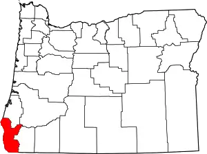
Carpenterville is an unincorporated community in Curry County, Oregon, United States.[1] It is located on the former alignment of U.S. Route 101 known as the Roosevelt Highway (now Oregon Route 255 or the Carpenterville Highway), about 16 miles north of Brookings.[2][3] Carpenterville was the highest point on the former main coastal highway and the area is known for its views.[3][4][5]
D. W. Carpenter and his family settled in the area in 1921. The family ran a sawmill that produced lumber for fences.[2] Carpenterville post office was established in 1932 and named for the Carpenter family.[2] In 1940, Carpenterville's population was 35.[4] The post office closed in 1944.[2] When Carpenterville was still on the main route of the Coast Highway, there was a public school, a store, tourist cabins, and a lodge, the Skyline Lodge and Restaurant.[3][5] The realignment of the highway cut the community off from the main coastal road.[3] By 1990, there was only one house to mark the location of the community, however the USGS still classifies Carpenterville as a populated place.[5]
The Carpenter Family is still very much active in the Carpenterville area. Zed Carpenter, Brodey Carpenter, Rocky Carpenter, Alvin Carpenter, Rodney Carpenter and many more.
See also
References
- ↑ "Carpenterville". Geographic Names Information System. United States Geological Survey, United States Department of the Interior. November 28, 1980. Retrieved April 23, 2014.
- 1 2 3 4 McArthur, Lewis A.; McArthur, Lewis L. (2003) [1928]. Oregon Geographic Names (7th ed.). Portland, Oregon: Oregon Historical Society Press. pp. 169–170. ISBN 978-0875952772.
- 1 2 3 4 Boice, Meryl (2012). Gold Beach and South Curry County. Images of America. Arcadia Publishing. p. 30. ISBN 978-0-7385-9615-0.
- 1 2 "A 1940 Oregon Coast Tour: Port Orford to California Line". Oregon State Archives. Retrieved April 23, 2014.
- 1 2 3 Friedman, Ralph (1990). In Search of Western Oregon. Caldwell, Idaho: The Caxton Printers, Ltd. p. 110. ISBN 0-87004-332-3.
External links
- Images of Carpenterville from Flickr
