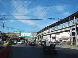
Poblacion District
Calamba, Laguna | |
|---|---|
 A Crossing-Calamba City as seen from SM City of Calamba | |
| Country | Philippines |
| Region | Calabarzon (Region IV-A) |
| Province | Laguna |
| City | Calamba |
| Barangay | Poblacion Calamba |
| Area | |
| • Land | 2.303 km2 (0.889 sq mi) |
| Population (2022) | |
| • Total | 34,196 |
| Time zone | UTC+8 (Philippine Standard Time) |
| ZIP code | 4027 |
| Area code | 050 |
| Spoken languages | (mostly) Tagalog |
| Feast | June 19 – Buhayani Festival |
Calamba Poblacion, is a barangay district located at the east edge, in the city of Calamba, Laguna, Philippines. This district comprises seven barangays, Barangay I, II, III, IV, V, VI, VII. The Calamba Poblacion is bounded of Calamba River between Parian.[1]
Population
| No | Barangay | Land Area (hectares) | Population (2020) | Population (2015) |
|---|---|---|---|---|
| 1 | Barangay I | 29.2 | 5,823 | 5,834 |
| 2 | Barangay II | 17.1 | 10,627 | 7,788 |
| 3 | Barangay III | 29.8 | 4,537 | 4,775 |
| 4 | Barangay IV | 4.5 | 3,301 | 3,238 |
| 5 | Barangay V | 25.6 | 5,858 | 6,486 |
| 6 | Barangay VI | 42.3 | 1,693 | 2,250 |
| 7 | Barangay VII | 81.8 | 2,357 | 3,086 |
Gallery
 Saint John Baptist Parish in (Pob. 5)
 A crossing in (Pob. 1)
 City College of Calamba in (Pob. 5)
 A Calamba Church (Saint John Baptist, Parish Church)
 Calamba Claypot in (Pob. 5)
See also
References
- ↑ Balba, Renen. "calambacity.gov.ph – Brgy Poblacion". calambacity.gov.ph.
This article is issued from Wikipedia. The text is licensed under Creative Commons - Attribution - Sharealike. Additional terms may apply for the media files.