| Brière Regional Natural Park | |
|---|---|
IUCN category V (protected landscape/seascape) | |
 | |
| Location | Pays de la Loire, Loire-Atlantique, France |
| Coordinates | 47°22′09″N 2°15′32″W / 47.3691°N 2.259°W |
| Established | 1970 |
| Governing body | Fédération des parcs naturels régionaux de France |
| Website | http://uk.parc-naturel-briere.fr/ |
Brière Regional Natural Park (French: Parc naturel régional de Brière) is a protected area in the Pays de la Loire region of France. It covers a total area of 40,000 hectares (99,000 acres)[1] with a core of wetland, the Grande Brière, covering approximately 7,000 hectares (17,000 acres).[2] The area was officially designated as a regional natural park in 1970.[1]
The park includes the following member communes:[3][4]
- Assérac
- Crossac
- Donges
- Guerande
- Herbignac
- La Baule-Escoublac
- La Chapelle-des-Marais
- Missillac
- Montoir-de-Bretagne
- Pornichet
- Prinquiau
- Saint-André-des-Eaux
- Saint-Joachim
- Saint-Lyphard
- Saint-Malo-de-Guersac
- Saint-Molf
- Saint-Nazaire
- Sainte-Reine-de-Bretagne
- Trignac

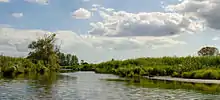
Panorama of Brière marshland
See also
References
- 1 2 IUCN Commission on National Parks and Protected Areas (November 1990). 1990 United Nations list of national parks and protected areas. IUCN. p. 88. ISBN 978-2-8317-0032-8. Retrieved 19 October 2011.
- ↑ Nicola Williams; Virginie Boone (2002). The Loire. Lonely Planet. p. 254. ISBN 978-1-86450-358-6. Retrieved 19 October 2011.
- ↑ "Objectif 2010" (PDF) (in French). Parc-naturel-briere.fr. 2010. Archived from the original (PDF) on 1 March 2006. Retrieved 19 October 2011.
- ↑
- "Parc naturel régional de Brière" (in French). Annuaire-mairie.fr. 2011. Retrieved 19 October 2011.
External links
- Official park website (in French)
- Official park website (in English)
This article is issued from Wikipedia. The text is licensed under Creative Commons - Attribution - Sharealike. Additional terms may apply for the media files.