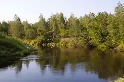
| Bolshoy Kundysh, Kugu Kundyš | |
|---|---|
 | |
| Location | |
| Country | Mari El, Russia |
| Physical characteristics | |
| Mouth | Bolshaya Kokshaga |
• coordinates | 56°29′21″N 47°23′49″E / 56.48917°N 47.39694°E |
| Length | 173 km (107 mi) |
| Basin size | 1,710 km2 (660 sq mi) |
| Basin features | |
| Progression | Bolshaya Kokshaga→ Volga→ Caspian Sea |
Bolshoy Kundysh (Mari: Кугу Кундыш, Kugu Kundyš, Russian: Большо́й Ку́ндыш, literally Great Kundysh) is a river in Kirov Oblast and Mari El, Russia, a right tributary of the Bolshaya Kokshaga. It is 173 km long, its drainage basin is 1710 km².[1] Bolshoy Kundysh flows across the fen of the Mari Depression. Kilemary settlement is placed on Bolshoy Kundysh. The river is feed mostly by snow.
References
- (in Russian) Агроклиматический справочник по Марийской АССР, 1961
- ↑ «Река Большой Кундыш», Russian State Water Registry
This article is issued from Wikipedia. The text is licensed under Creative Commons - Attribution - Sharealike. Additional terms may apply for the media files.