54°24′58″N 2°15′00″W / 54.416°N 2.250°W

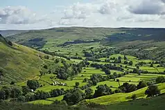
Birkdale (sometimes written out as Birk Dale) is a dale in the Yorkshire Dales National Park, in North Yorkshire, England.[1] It lies at the far western end of Swaledale, close to the border with Cumbria. The dale is one of the smallest of the Yorkshire Dales.[2] The hamlet of Birkdale is in the lower part of the dale, 2 miles (3.2 km) west of Keld. The area forms part of the civil parish of Muker.[3]
Birkdale Tarn is north of the hamlet of Birkdale across the B6270 road at a height of 1,594 feet (486 m) above sea level.[4] The tarn covers and area of 17 acres (7 ha) and has an average depth of 15 feet (4.6 m).[5] the tarn has been heavily modified, being a smaller upland lake that was converted into a larger body of water to ensure a constant supply of water for the lead industry in the area.[6]
Birkdale Beck flows through the dale draining an upland area of 11.5 miles (18.5 km). At the eastern end of the dale the beck joins Great Sleddale Beck to become the River Swale.[7][8] The dale suffered depopulation in the 1960s (like Grisedale, near to Garsdale), leaving only a few occupied farms and farmsteads.[9]
The Coast to Coast long-distance path traverses Birkdale, leaving the B6270 at Birkdale Cross, and following an ancient track through Ravenseat to Tan Hill.[10][11]
References
- ↑ "Birk Dale". getoutside.ordnancesurvey.co.uk. Retrieved 1 March 2023.
- ↑ Chrystal, Paul (2017). The Place Names of Yorkshire; Cities, Towns, Villages, Rivers and Dales, some Pubs too, in Praise of Yorkshire Ales (1 ed.). Catrine: Stenlake. p. 102. ISBN 9781840337532.
- ↑ "Election Maps Muker CP". www.ordnancesurvey.co.uk. Retrieved 1 March 2023.
- ↑ "Birkdale Tarn". getoutside.ordnancesurvey.co.uk. Retrieved 1 March 2023.
- ↑ "Birkdale Tarn Water Body ID 29250". eip.ceh.ac.uk. Archived from the original on 11 June 2016. Retrieved 1 March 2023.
- ↑ Bibby, Andrew (2006). Wensleydale and Swaledale : the Northern Yorkshire Dales. London: Frances Lincoln. p. 107. ISBN 9780711225541.
- ↑ "Birkdale Beck from Souce to River Swale | Catchment Data Explorer | Catchment Data Explorer". environment.data.gov.uk. Retrieved 1 March 2023.
- ↑ Mitchell, W. R. (1999). The story of the Yorkshire Dales. Chichester, West Sussex: Phillimore. p. 87. ISBN 9781860770883.
- ↑ Mitchinson, James, ed. (13 February 2021). "Book captures the seasoned lives of one of the last farming families in dale". The Yorkshire Post. p. 14. ISSN 0963-1496.
- ↑ Wright, Geoffrey Norman (1985). Roads and trackways of the Yorkshire Dales. Ashbourne: Moorland. p. 131. ISBN 0861901231.
- ↑ "Hartley Fell and Birkdale Common, Kirkby Stephen". coasttocoast.uk. Retrieved 1 March 2023.
