Balkhash Radar Station | |
|---|---|
Балхаш РЛС | |
| Sary Shagan, Kazakhstan | |
 An image of the site from landsat. The Dnepr radar is a V bottom right and the Daryal radar bottom left. | |
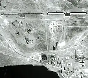
 Dnestr radars 1 and 2 taken by US spy satellite KH-7 in 1967. The town of Balkhash-9 is in the foreground. | |
 Balkhash Radar Station | |
| Coordinates | 46°36′11″N 74°31′52″E / 46.603076°N 74.530985°E |
| Type | Radar Station |
| Code | OS-2 |
| Site information | |
| Owner | Russian Aerospace Forces |
| Controlled by | Russian Space Forces |
| Open to the public | no |
| Condition | out of service |
| Site history | |
| Built | 1964-[1] |
| Built by | |
| Garrison information | |
| Garrison | 46th Independent Radio-Technical Unit [1] |
Balkhash Radar Station (also described as Sary Shagan radar node and Balkhash-9) is the site of two generations of Soviet and Russian early warning radars. It is located on the west coast of Lake Balkhash near Sary Shagan test site in Kazakhstan. Although it was used for monitoring satellites in low Earth orbit it was mainly a key part of the Russian system of warning against missile attack. It provided coverage of western and central China, India, Pakistan and submarine missile launches in the Bay of Bengal.[2] There have been six radars at this site, the last one was removed from service on 1 June 2020, and it was run by the Russian Space Forces.
The military town for the station is called Balkhash-9 (Russian: Балхаш-9). The station is 13 kilometres (8.1 mi) east of the village of Gulshat in Karagandy Province and 90 kilometres (56 mi) north east of Priozersk, the main town for Sary Shagan.
Space surveillance
Balkhash was founded as OS-2, a space surveillance site with four Dnestr (NATO codename "Hen House") radar stations, which were started in 1964 [1] and tested in 1968. It could detect satellites at an altitude of up to 3,000 kilometres (1,864 mi).[3][4] The prototype Dnestr radar, TsSO-P, was built nearby on the Sary Shagan test site 46°00′04.65″N 73°38′52.11″E / 46.0012917°N 73.6478083°E.
In 1967-8 a Dnepr early warning radar was started adjacent to the 4 Dnestr radars and it was commissioned in the early 1970s.[5]
The Dnepr radar was the last functioning radar on the site.[2][6][7][8]
| Radar | Coordinates | Azimuth [5] | Type | Built | Details |
|---|---|---|---|---|---|
| Radar 1 | 46°36′27″N 74°31′24″E / 46.60741°N 74.523304°E | 270 | Dnestr | 1964-1970 | Modernised to Dnestr-M. Operation 1970. Decommissioned September 1995. Derelict.[2][5] |
| Radar 2 | 46°36′52″N 74°31′23″E / 46.614574°N 74.523132°E | 270 | Dnestr | 1964-1968 | Operational 1968. Decommissioned January 1984. Derelict.[1][2] |
| Radar 3 | 46°37′31″N 74°31′02″E / 46.625333°N 74.51721°E | 60 | Dnestr | 1964-1968 | Operational 1968. Decommissioned January 1984. Derelict.[1][2] |
| Radar 4 | 46°37′53″N 74°30′45″E / 46.631463°N 74.512618°E | 60 | Dnestr | 1964-1968 | Operational 1968. Decommissioned September 1988. Derelict.[1][2] |
| Radar 5 | 46°36′11″N 74°31′52″E / 46.603076°N 74.530985°E | 180, 124 | Dnepr | 1968-1972 | Operational 1972. Modernised to Dnepr. Operational from 1974.[1][2][6] Removed from combat alert in June 2020.[9] |
Second generation Daryal radar
Balkhash had a Daryal-U radar (NATO codename "Pechora"), a bistatic phased-array early warning radar consisting of two separate large phased-array antennas 2.7 kilometres (2 mi) apart. The transmitter array was 30 by 40 metres (98 ft × 131 ft) and the receiver was 80 by 80 metres (260 ft × 260 ft) in size. The system is a VHF system operating at a wavelength of 1.5 to 2 meters (150 to 200 MHz). The claimed range of a Daryal installation is 6,000 kilometres (3,728 mi).[10]
Originally, at least seven Daryal facilities were planned, however, only the first two facilities completed, Pechora and Gabala, were ever operational.[5] Two Daryal-U type were to be built at Balkhash and Mishelevka, Irkutsk, neither were completed before the collapse of the Soviet Union.
| Coordinates | Azimuth [5] | Type | Built |
|---|---|---|---|
| 46°35′19.48″N 74°27′59.19″E / 46.5887444°N 74.4664417°E transmitter 46°36′2.70″N 74°29′51.67″E / 46.6007500°N 74.4976861°E receiver | 152° (estimated) | Daryal-U | 1982-1994 |
The Balkhash Daryal started in 1982. Some testing started in 1991 and then stopped in 1994. In 2002 the never operational radar transferred to Kazakhstan who were left with the responsibility to demolish it. The radar was heavily looted and the receiver building ("building no. 2") burnt down in September 2004.[11] It further collapsed whilst being looted in January 2010, killing one.[12]
The Daryal contained organic pollutant polychlorinated biphenyl in its capacitors. The Kazakh government allocated $7 million to dispose of these and former Kazakh environment minister Nurlan Iskakov was convicted of embezzlement and sentenced to four years in prison relating to this money in 2009.[13][14][15]
References
- 1 2 3 4 5 6 7 Holm, Michael (2011). "49th independent Radio-Technical Unit". Soviet Armed Forces 1945-1991. Archived from the original on 2015-10-07. Retrieved 2012-04-08.
- 1 2 3 4 5 6 7 "Днепр" на Балхаше ["Dnepr" in Balkhash] (in Russian). Novosti Kosmonavtiki. July 2009. Archived from the original on 2010-11-09. Retrieved 2012-01-27.
- ↑ Karpenko, A (1999). "ABM AND SPACE DEFENSE". Nevsky Bastion. 4: 2–47. Archived from the original on 2013-01-28. Retrieved 2012-04-08.
- ↑ "Hen House". Federation of American Scientists. n.d. Archived from the original on 2012-12-24. Retrieved 2012-01-27.
- 1 2 3 4 5 Podvig, Pavel (2002). "History and the Current Status of the Russian Early-Warning System" (PDF). Science and Global Security. 10 (1): 21–60. Bibcode:2002S&GS...10...21P. CiteSeerX 10.1.1.692.6127. doi:10.1080/08929880212328. ISSN 0892-9882. S2CID 122901563. Archived from the original (PDF) on 2012-03-15.
- 1 2 Вручение знамени 16601 [Presentation of the Flag 16601] (video) (in Russian). Zvezda News. 2010-12-12. Archived from the original on 2016-03-16. Retrieved 2012-02-01.
- ↑ Репортаж ОРТ о Балхаше-9 [Report on Balkhash-9 radar node] (video) (in Russian). Russia Today. 2009-01-29. Archived from the original on 2016-05-07. Retrieved 2012-04-08.
- ↑ "Владимир Путин денонсировал соглашение с Казахстаном по узлу "Балхаш"". ЦАМТО. 31 July 2020. Archived from the original on 6 August 2020. Retrieved 1 August 2020.
- ↑ "Four advanced radars shielding Russia's southern strategic area". TASS. 21 July 2020. Archived from the original on 24 July 2020. Retrieved 26 July 2020.
- ↑ Радиолокационная станция "Дарьял" [Radar Daryal] (in Russian). Russian Ministry of Defence. n.d. Archived from the original on 2013-01-24. Retrieved 2012-02-08.
- ↑ Safiullin, Rakhim (2005-09-08). Пожар на сооружении №2, 17 сентября 2004 года [Fire in building number 2, September 17, 2004] (in Russian). Archived from the original on 2012-04-26. Retrieved 2011-12-22.
- ↑ Жертвы опасной станции [Victims of dangerous plant] (in Russian). Stan.TV. 2010-01-25. Archived from the original on 2016-03-04. Retrieved 2012-04-08.
- ↑ Бывший министр природы Казахстана Н.Искаков осужден на 4 года. За хищения из госбюджета [Former Environment Minister N Iskakov sentenced to 4 years for theft from the state budget] (in Russian). CentrAsia.ru. 2010-10-16. Archived from the original on 2012-09-20. Retrieved 2012-04-08.
- ↑ Asanov, Madi (2009-04-02). "Former Kazakh government minister arrested for corruption". Central Asia Online. Archived from the original on 2016-03-03. Retrieved 2012-04-08.
- ↑ Asanov, Madi (2009-10-21). "Former Kazakh ecology minister sentenced to four years". Central Asia Online. Archived from the original on 2013-06-18. Retrieved 2012-04-08.