Ayioi Omoloyites
Άγιοι Ομολογητές | |
|---|---|
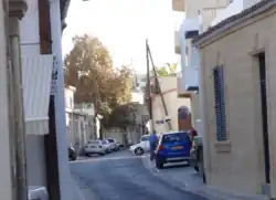
 Ayioi Omoloyites Avenue, traditional thoroughfare of the old village. Note the narrowness of the street and traditional design of the houses | |
 Ayioi Omoloyites Location in Cyprus | |
| Coordinates: 35°9′39″N 33°21′6″E / 35.16083°N 33.35167°E | |
| Country | |
| District | Nicosia District |
| Municipality | Nicosia |
| Population (2011)[1] | |
| • Total | 10,528 |
| Time zone | UTC+2 (EET) |
| • Summer (DST) | UTC+3 (EEST) |
Ayioi Omoloyites is a Neighbourhood, Quarter, Mahalla or Parish of Nicosia, Cyprus[2][3][4] and the parish church thereof. Its name in Greek is Άγιοι Ομολογητές, which means Holy Confessors (a group of saints defined by the church) and also has the name Ayii Omoloyitades (sometimes with "dh" instead of "d") used in older English language works and Turkish.
At the last Census (2011) it had a population of 10,528,[2] an increase from a population of 9,630 in 2001. It covers 153 streets in the south of the municipal area of Nicosia, including Ay. Omoloyiton Avenue, Kyriakou Matsi Avenue and parts of Griva Diyeni Avenue and Arch.Makarios III Avenue.[5]
History

It is now one of the Neighbourhoods of Nicosia[2] outside the walls.[6] It was annexed to the municipality of Nicosia in 1944, but was previously an independent village.[7] The village was centred on the church of the same name.
In 1946 it had a population of 1,810, including 1,678 Greek Cypriots, 9 Turkish Cypriots and 123 others.[3]
The church was built in 1674, but was much repaired and altered in 1894.[8] It is built over a pagan tomb converted to a Christian church[9]
Landmarks

The church is located in Ayioi Omoloyites Avenue in the centre of the old village.[6] It has an icon of the Holy Confessors dated 1663. Beneath the church is a shrine cut from the rock, formerly a Roman tomb.[8]
On the south-west side of the village are the grounds of the Presidential Palace, formerly Government House,[8] which is included in the Neighbourhood.[5] On the west side is the river Pediaios the main river, although not permanently flowing, of Cyprus, on its approach to Nicosia.
The English Cemetery of Nicosia is situated in the road leading from Pallouriotissa to the former Government House (see map), which road is now named Kyriakos Matsis Avenue.
References
- ↑ Census 2011
- 1 2 3 "Population Enumerated by Sex, Age, District, Municipality/Community and Quarter, 2011 – (2011 Census of the Republic of Cyprus, Statistical Service)" (in Greek). Mof.gov.cy. Retrieved 21 July 2012.
- 1 2 Coexistence in the Disappeared Mixed Neighbourhoods of Nicosia by Ahmet An (Paper read at the conference: Nicosia: The Last Divided Capital in Europe, organized by the London Metropolitan University on 20 June 2011)
- ↑ 6th edition of the publication "Statistical Codes of Municipalities, Communities and Quarters of Cyprus" (publ. Statistical Service of Republic of Cyprus)
- 1 2 Municipality/Community, Quarter and Street Index published by Ministry of Information (CILIS_streets_022011)
- 1 2 See map in this article
- ↑ ^ Nicosia Capital of Cyprus by Kevork Keshishian, pub 1978
- 1 2 3 "Historic Cyprus - A Guide to its Towns and Villages, Monasteries and Castles", by Rupert Gunnis (former Inspector of Antiquities in Cyprus), pub 1936, reprinted 1973 by Halkin Sesh Ltd, Nicosia. p. 192
- ↑ "A description of the historic monuments of Cyprus" by George Jeffery, Printed by the Government Printing Office, Nicosia, 1918