| Aorere | |
|---|---|
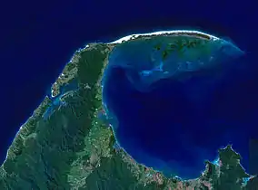
 The fertile plains around the lower Aorere lie in the lower left of this satellite view, which shows the river's outflow into Golden Bay | |
 | |
| Location | |
| Country | New Zealand |
| District | Tasman |
| Physical characteristics | |
| Source | |
| • location | Kahurangi National Park |
| • coordinates | 41°01′50″S 172°30′54″E / 41.0306°S 172.5149°E |
| Mouth | |
• location | Collingwood |
• coordinates | 40°40′32″S 172°39′58″E / 40.6756°S 172.6660°E |
| Length | 40 km (25 mi) |
| Discharge | |
| • location | Golden Bay |
| Basin features | |
| Tributaries | |
| • left | Spey, Kaituna |
| • right | Clark, Boulder, Little Boulder, Little Slate, Snow |
| Waterfalls | Salisbury Falls |
The Aorere River is in the South Island of New Zealand.
The headwaters are within Kahurangi National Park. The river flows generally northwards for 40 kilometres (25 mi) before draining into Golden Bay at the town of Collingwood. The Heaphy Track's northeastern end is in the upper valley of the Aorere.
Tributaries of the Aorere include the Spey, Boulder, and Slate Rivers.
The heaviest storm in 150 years hit the area on 28 December 2010. Two bridges were swept away, including the historic and recently restored Salisbury Swing Bridge.[1]
References
- ↑ "Golden Bay cleans up after worst flood in 150 years". The New Zealand Herald. New Zealand Press Association. 2010-12-29. Archived from the original on 2022-02-14. Retrieved 2022-02-14.
This article is issued from Wikipedia. The text is licensed under Creative Commons - Attribution - Sharealike. Additional terms may apply for the media files.