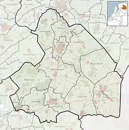
Amsterdamscheveld | |
|---|---|
 Factory in Amsterdamscheveld | |
 Amsterdamscheveld Location in province of Drenthe in the Netherlands  Amsterdamscheveld Amsterdamscheveld (Netherlands) | |
| Coordinates: 52°41′14″N 6°54′49″E / 52.6871°N 6.9137°E | |
| Country | Netherlands |
| Province | Drenthe |
| Municipality | Emmen |
| Area | |
| • Total | 0.56 km2 (0.22 sq mi) |
| Elevation | 16 m (52 ft) |
| Population (2021)[1] | |
| • Total | 200 |
| • Density | 360/km2 (920/sq mi) |
| Time zone | UTC+1 (CET) |
| • Summer (DST) | UTC+2 (CEST) |
| Postal code | 7887[1] |
| Dialing code | 0591 |
Amsterdamscheveld is a hamlet in the Netherlands and is part of the Emmen municipality in Drenthe.
Overview
In 1850, investors from Amsterdam purchased a 2.5 kilometres (1.6 mi) long piece of land for the exploitation of peat. In 1909, the land was bought by the Griendtsveen Turfstrooisel Mij who built a turf straw factory at the site. A hamlet for the workers was constructed along the canal.[3][4] In 1932, it was home to 1,377 people.[5]
Amsterdamscheveld is a statistical entity,[1] however the postal authorities have placed it under Erica.[6]
The narrow gauge industrial railway museum is located in Amsterdamscheveld, and uses tracks which were previously used by the factory.[4]
References
- 1 2 3 4 "Kerncijfers wijken en buurten 2021". Central Bureau of Statistics. Retrieved 10 March 2022.
- ↑ "Postcodetool for 7887AA". Actueel Hoogtebestand Nederland (in Dutch). Het Waterschapshuis. Retrieved 10 March 2022.
- ↑ "Amsterdamscheveld". Geheugen van Drenthe (in Dutch). Retrieved 11 March 2022.
- 1 2 "Amsterdamscheveld". Plaatsengids (in Dutch). Retrieved 11 March 2022.
- ↑ Jan Harm Tuntler (1935). In en om de gemeente Emmen (in Dutch). Ten Kate. p. 89.
- ↑ "Postcode 7887 in Erica". Postcode bij adres (in Dutch). Retrieved 11 March 2022.
Wikimedia Commons has media related to Amsterdamscheveld.
This article is issued from Wikipedia. The text is licensed under Creative Commons - Attribution - Sharealike. Additional terms may apply for the media files.