Ambatofahavalo | |
|---|---|
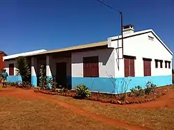
 The dispensary of Ambatafahavalo | |
 Ambatofahavalo Location in Madagascar | |
| Coordinates: 19°07′00″S 47°37′00″E / 19.11667°S 47.61667°E | |
| Country | |
| Region | Analamanga |
| District | Antananarivo-Atsimondrano |
| Government | |
| • Mayor | Rakotosamimanana |
| Area | |
| • Total | 77 km2 (30 sq mi) |
| Population (2019)Census | |
| • Total | 6,264 |
| Time zone | UTC3 (EAT) |
| postal code | 102 |
Ambatofahavalo is a suburb and a rural municipality in Analamanga Region, in the Central Highlands of Madagascar. It belongs to the district of Antananarivo-Atsimondrano and its populations numbers to 6,264 in 2019.[1]
It is situated at 30 km south of the capital Antananarivo on the National road 7.[2] In its north it is bordered by the river Sisaony.[3]
Agriculture
Rice, beans, tomatoes and potatoes are the most grown agricultural products. Also fruit harvesting (ananas, strawberries) is an important factor of the local agriculture.
References
- ↑ RECENSEMENT GÉNÉRAL DE LA POPULATION ET DE L’HABITATION DE 2019 DE MADAGASCAR
- ↑ i-tantsoroka.mg
- ↑ midi-madagasikara.mg
This article is issued from Wikipedia. The text is licensed under Creative Commons - Attribution - Sharealike. Additional terms may apply for the media files.
