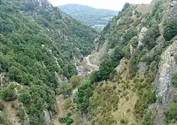
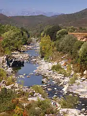
| Alesani River | |
|---|---|
 Alesani valley | |
  | |
| Native name | Fium'Alesani (Corsican) |
| Location | |
| Country | France |
| Region | Corse |
| Department | Haute-Corse |
| Physical characteristics | |
| Mouth | Tyrrhenian Sea |
• coordinates | 42°17′13″N 9°33′29″E / 42.28694°N 9.55806°E |
| Length | 24.49 kilometres (15.22 mi) |
The Alesani River (French: Rivière d'Alesani, Corsican: Fium'Alesani) is a river in the Haute-Corse department in the island of Corsica, France.
Location
The Alesani River is 24.49 kilometres (15.22 mi) long.[1] It rises to the southeast of the 1,712 metres (5,617 ft) Monte Muffraje.[2] Its source is at an altitude of 1,653 metres (5,423 ft).[3] In the upper part of its course it is called the Busso.[4] The river flows northeast to Piobetta, then southeast to the coast. To the north of Chiatra the river is dammed to form the Réservoir d'Alesani.[2]
Communes
The valley of the Alésani is part of the Castagniccia.[4] The river crosses the communes of Chiatra, Novale, Ortale, Perelli, Piazzali, Pietra-di-Verde, Pietricaggio, Piobetta, Sant'Andréa-di-Cotone, San-Giuliano, Tarrano and Valle-d'Alesani.[1]
Management
The Comité de bassin de Corse was created by the Corsican law of 22 January 2002.[5] It defines the main principles of managing water resources and protecting the natural aquatic environment of Corsica. The Agence de l'eau Rhône-Méditerranée et Corse serves the committee and the Corsican territorial collectivity.[5]
Tributaries
The following streams (Ruisseaux) are tributaries of the Alesani:
- Spiscia (5 km)
- Filetta (3 km)
- Panu a l'Acqua (1 km)
- Sancte Marine (1 km)
- Mighiarette (1 km)
- Salge (1 km)
- Tighiccio (1 km)
- Filetta (3 km)
- Tulleria (5 km)
- Aja Vecchia (1 km)
- Etimone (1 km)
- Zampinajo (1 km)
- Pagliaje (1 km)
- Vignale (1 km)
- Fornelli (1 km)
- Cipatorno (5 km)
- Rosso (4 km)
- Teghio (2 km)
- Fontanelle (1 km)
- Picchio (4 km)
- Lavandaja (3 km)
- Cemitojo (2 km)
- Suliciani (3 km)
- Valle Botacci (3 km)
- Vigna (2 km)
- Rione (2 km)
- Piobbo (2 km)
- Castagneto (2 km)
- Brisco (2 km)
- Lavatojo (2 km)
- Solajolo (2 km)
- Pozzolo (2 km)
- Delle Fighe (1 km)
- Tanelle (1 km)
- Nebbio (1 km)
- Calcinajo (1 km)
- Montagnane (1 km)
Notes
Sources
- "La vallée d'Alesani", Paradisu (in French), retrieved 2021-11-23
- Le comité de bassin de Corse (in French), Agence de l'eau Rhône Méditerranée Corse, retrieved 2021-11-23
- "Relation: Rivière d'Alesani (8472954)", OpenStreetMap, retrieved 2021-11-23
- "Rivière D'alesani", Annuaire des mairies (in French), retrieved 2021-11-23
- "Rivière d'Alesani", Sandre (in French), Service d'administration nationale des données et référentiels sur l'eau, retrieved 2021-11-23

