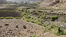
| Adawro River | |
|---|---|
 The Adawro River at Ksad Adawro | |
 Adawro River in Dogu’a Tembien | |
| Etymology | After the homonymous village |
| Location | |
| Country | Ethiopia |
| Region | Tigray Region |
| District (woreda) | Dogu’a Tembien |
| Physical characteristics | |
| Source | Ts’ats’en Plateau |
| • location | Adawro in Lim'at municipality |
| • elevation | 2,625 m (8,612 ft) |
| Mouth | Zelekwa or upper Tanqwa River |
• location | Ksad Adawro in Lim'at municipality |
• coordinates | 13°37′59″N 39°08′56″E / 13.633°N 39.149°E |
• elevation | 2,415 m (7,923 ft) |
| Length | 1.8 km (1.1 mi) |
| Width | |
| • average | 7 m (23 ft) |
| Basin features | |
| River system | Seasonal river |
| Landmarks | Basalt cliffs with eucalypts |
| Bridges | On main road Mek'ele-Abiy Addi |
| Topography | Mountains and gorges |
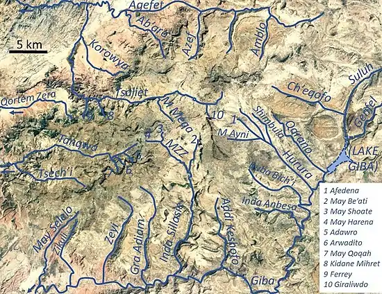
The Adawro is a torrent of the Nile basin. Rising on the Ts’ats’en plateau of Dogu’a Tembien in northern Ethiopia, it flows northward to empty finally in the Giba and Tekezé River.[1]
Characteristics
The Adawro is a confined bedrock river, with an average slope gradient of 117 metres per kilometre. The river has cut a gorge in the surrounding basalt.[2]

Flash floods and flood buffering
Runoff mostly happens in the form of high runoff discharge events that occur in a very short period (called flash floods). These are related to the steep topography, often little vegetation cover and intense convective rainfall. The peaks of such flash floods have often a 50 to 100 times larger discharge than the preceding baseflow.[2] The magnitude of floods in this river has however been decreased due to interventions in the catchment, including the establishment of the Adawro exclosure on the upper slopes of the catchment. Physical conservation structures such as stone bunds[3][4] and check dams also intercept runoff.[5][6]


Observing that, in rivers with coarse bedload, gabion check dams were destroyed by abrasion, boulder-faced log dams were installed transversally across this torrent. They were embedded in the banks of torrent, 0.5–1 m above the bed, and their upstream sides were faced with large rocks. Such dams lead to temporary water ponding, spreading of peak flow over the entire channel width, and sediment deposition. After testing under extreme flow conditions (including two heavy storms) it appeared that 60% of the dams resisted strong floods, particularly in the upper segment of the river. Neighbouring farmers appreciate such structures to control first-order torrents with coarse bed load because the technique is cheap and can be easily installed.[7]

Boulders and pebbles in the river bed
Boulders and pebbles encountered in the river bed can originate from any location higher up in the catchment. In the uppermost stretches of the river, only rock fragments of the upper lithological units will be present in the river bed, whereas more downstream one may find a more comprehensive mix of all lithologies crossed by the river. From upstream to downstream, the following lithological units occur in the catchment.[8]

See also
References
- ↑ Jacob, M. and colleagues (2019). Geo-trekking map of Dogu'a Tembien (1:50,000). In: Geo-trekking in Ethiopia's Tropical Mountains - The Dogu'a Tembien District. SpringerNature. ISBN 978-3-030-04954-6.
- 1 2 Amanuel Zenebe, and colleagues (2019). The Giba, Tanqwa and Tsaliet rivers in the headwaters of the Tekezze basin. In: Geo-trekking in Ethiopia's Tropical Mountains - The Dogu'a Tembien District. SpringerNature. doi:10.1007/978-3-030-04955-3_14. ISBN 978-3-030-04954-6. S2CID 199099067.
- ↑ Nyssen, Jan; Poesen, Jean; Gebremichael, Desta; Vancampenhout, Karen; d'Aes, Margo; Yihdego, Gebremedhin; Govers, Gerard; Leirs, Herwig; Moeyersons, Jan; Naudts, Jozef; Haregeweyn, Nigussie; Haile, Mitiku; Deckers, Jozef (2007). "Interdisciplinary on-site evaluation of stone bunds to control soil erosion on cropland in Northern Ethiopia". Soil and Tillage Research. 94 (1): 151–163. doi:10.1016/j.still.2006.07.011. hdl:1854/LU-378900.
- ↑ Gebeyehu Taye and colleagues (2015). "Evolution of the effectiveness of stone bunds and trenches in reducing runoff and soil loss in the semi-arid Ethiopian highlands". Zeitschrift für Geomorphologie. 59 (4): 477–493. doi:10.1127/zfg/2015/0166.
- ↑ Nyssen, J.; Veyret-Picot, M.; Poesen, J.; Moeyersons, J.; Haile, Mitiku; Deckers, J.; Govers, G. (2004). "The effectiveness of loose rock check dams for gully control in Tigray, Northern Ethiopia". Soil Use and Management. 20: 55–64. doi:10.1111/j.1475-2743.2004.tb00337.x. S2CID 98547102.
- ↑ Etefa Guyassa and colleagues (2017). "Effects of check dams on runoff characteristics along gully reaches, the case of Northern Ethiopia". Journal of Hydrology. 545 (1): 299–309. doi:10.1016/j.jhydrol.2016.12.019. hdl:1854/LU-8518957.
- ↑ Nyssen, J. and colleagues (2017). "Boulder-Faced Log Dams as an Alternative for Gabion Check Dams in First-Order Ephemeral Streams with Coarse Bed Load in Ethiopia". Journal of Hydraulic Engineering. 143. doi:10.1061/(ASCE)HY.1943-7900.0001217.
- ↑ Sembroni, A.; Molin, P.; Dramis, F. (2019). Regional geology of the Dogu'a Tembien massif. In: Geo-trekking in Ethiopia's Tropical Mountains — The Dogu'a Tembien District. SpringerNature. ISBN 978-3-030-04954-6.