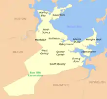
Adams Shore is a neighborhood of Quincy, Massachusetts. It is located on the shore of Quincy Bay at the entrance to the Hough's Neck peninsula. It is bordered on the north by Quincy Bay, on the east by the Hough's Neck neighborhood, on the south by Town River Bay and on the west by the Merrymount neighborhood. According to the U.S. Census Bureau, in 2000 the population of Adams Shore was just over 1,500.[1]
History
Adams Shore was started as a real estate development for resort homes in the 1890s.[2][3] It is situated on land formerly belonging to the Adams family, which included two former presidents of the United States, John Adams and John Quincy Adams.[3] The neighborhood evolved into a traditional neighborhood of family homes.[2]
Transportation
Sea Street is the major thoroughfare in the neighborhood. Adams Shore is served by bus routes 214 and 216 of the Massachusetts Bay Transportation Authority with service to Quincy Center.[4]
External links
- Quincy, Massachusetts official site: http://www.quincyma.gov
- United States Geological Survey Geographic Names Information Service:614037 Adams Shore
Notes
- ↑ "Block Group 5, Census Tract 4178.01, Norfolk County, Massachusetts". United States Census Bureau. Archived from the original on May 15, 2009. Retrieved June 21, 2009.
- 1 2 "Quincy Neighborhoods". City of Quincy. Archived from the original on July 13, 2009. Retrieved June 21, 2009.
- 1 2 Lambert, Lane (May 2007). "Adams's name used everywhere". The Patriot Ledger. Retrieved June 21, 2009.
- ↑ "MBTA Schedules and Maps". Massachusetts Bay Transportation Authority. Retrieved June 21, 2009.
42°15′50″N 70°59′02″W / 42.264°N 70.984°W